Geolocate

Sachseln topographic map

Click on the map to display elevation.

About this map

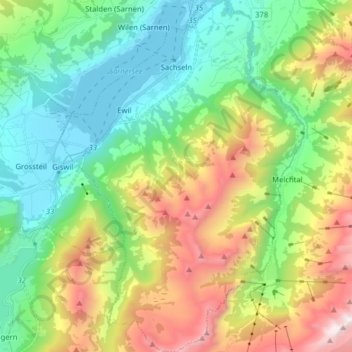
Name: Sachseln topographic map, elevation, terrain.

Location: Sachseln, Obwalden, Switzerland (46.78105 8.18644 46.88948 8.29709)

Average elevation: 1,142 m

Minimum elevation: 467 m

Maximum elevation: 2,473 m

Other topographic maps

Click on a map to view its topography, its elevation and its terrain.

Alpnachstad

Switzerland > Obwalden > Alpnach

Average elevation: 765 m

Gear up for your next adventure:

🧦Crew Hiking Socks - Comfortable socks for long-distance hikes
Camping Tent - Weather-resistant tents suitable for 2 to 6 people
💧Hydration Pack - Hands-free hydration system for long hikes
🕶️Polarized Sunglasses - Reduces glare from snow and water at high elevations
🕶️Polarized Sunglasses - Protect your eyes with durable polarized lenses

As an Amazon Associate, this site earns from qualifying purchases at no extra cost to you.