Geolocate

Shelton topographic map

Click on the map to display elevation.

About this map

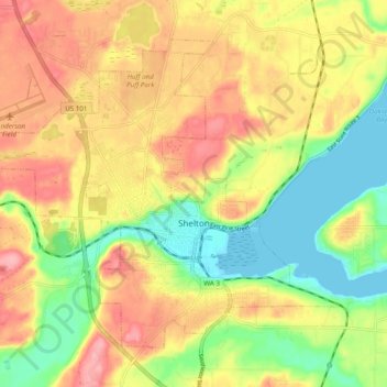
Name: Shelton topographic map, elevation, terrain.

Location: Shelton, Mason County, Washington, United States (47.19362 -123.16113 47.24668 -123.06343)

Average elevation: 54 m

Minimum elevation: -1 m

Maximum elevation: 106 m

Other topographic maps

Click on a map to view its topography, its elevation and its terrain.

Allyn

United States > Washington > Mason County

Average elevation: 45 m

Melbourne Lake

United States > Washington > Mason County

Average elevation: 255 m

Gear up for your next adventure:

💧Reusable Water Bottle - Durable water bottles for hydration on trails
🦯Trekking Poles - Reduced impact on joints for steep topographic climbs
🛰️Satellite Messenger - Emergency communication for areas with no cell service
🎒Fully Waterproof Backpack - Total protection for photography gear and electronics
🔦LED Flashlight - Powerful and long-lasting flashlight for camping and emergencies

As an Amazon Associate, this site earns from qualifying purchases at no extra cost to you.