Geolocate

Colyton topographic map

Click on the map to display elevation.

About this map

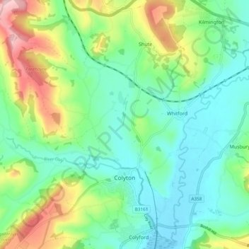
Name: Colyton topographic map, elevation, terrain.

Location: Colyton, East Devon, Devon, England, United Kingdom (50.72766 -3.14178 50.77899 -3.04752)

Average elevation: 67 m

Minimum elevation: -1 m

Maximum elevation: 225 m

Other topographic maps

Click on a map to view its topography, its elevation and its terrain.

Burrow

United Kingdom > England > Devon > East Devon > Broadclyst > Burrow

Average elevation: 30 m

Gear up for your next adventure:

🧊Portable Cooler - Keep food and drinks cold during outdoor adventures
💡LED Camping Lantern - Illuminate your campsite with long-lasting lanterns
🐕Hiking Dog Pack - Let your canine companion carry their own water and food
Camping Tent - Weather-resistant tents suitable for 2 to 6 people
🥾Waterproof Trail Shoes - Shoes designed to handle wet terrain

As an Amazon Associate, this site earns from qualifying purchases at no extra cost to you.