Geolocate

Edmondsham topographic map

Click on the map to display elevation.

About this map

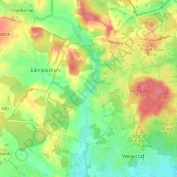
Name: Edmondsham topographic map, elevation, terrain.

Location: Edmondsham, Dorset, England, United Kingdom (50.87861 -1.93900 50.91733 -1.86455)

Average elevation: 62 m

Minimum elevation: 28 m

Maximum elevation: 102 m

Gear up for your next adventure:

🥘Camping Cookware Set - Compact nesting pots and pans for trail cooking
🔭Compact Binoculars - Lightweight optics for scouting trails and wildlife
🔋Emergency Crank Radio - Weather alerts and power without needing batteries
🔪Outdoor Multitool - Versatile tool for repairs and food prep in the wild
🥾Hiking Leggings - Comfortable leggings for outdoor activities

As an Amazon Associate, this site earns from qualifying purchases at no extra cost to you.