
McDonald's Corners topographic map
Interactive map
Click on the map to display elevation.
About this map
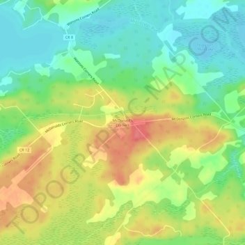
Name: McDonald's Corners topographic map, elevation, terrain.
Average elevation: 183 m
Minimum elevation: 153 m
Maximum elevation: 220 m
Other topographic maps
Click on a map to view its topography, its elevation and its terrain.
Watsons Corners
Canada > Ontario > Lanark County > Lanark Highlands
Watsons Corners, Lanark Highlands, Lanark County, Eastern Ontario, Ontario, Canada
Average elevation: 192 m
Darling
Canada > Ontario > Lanark County > Lanark Highlands
Darling, Lanark Highlands, Lanark County, Eastern Ontario, Ontario, Canada
Average elevation: 203 m
Folger
Canada > Ontario > Lanark County > Lanark Highlands
Folger, Lanark Highlands, Lanark County, Eastern Ontario, Ontario, Canada
Average elevation: 270 m
Lavant
Canada > Ontario > Lanark County > Lanark Highlands
Lavant, Lanark Highlands, Lanark County, Eastern Ontario, Ontario, Canada
Average elevation: 295 m
Flower Station
Canada > Ontario > Lanark County > Lanark Highlands > Flower Station
Flower Station, Lanark Highlands, Lanark County, Eastern Ontario, Ontario, Canada
Average elevation: 234 m
Patterson Lake
Canada > Ontario > Lanark County > Lanark Highlands
Patterson Lake, Lanark Highlands, Lanark County, Eastern Ontario, Ontario, Canada
Average elevation: 217 m
Elphin
Canada > Ontario > Lanark County > Lanark Highlands > Elphin
Elphin, Lanark Highlands, Lanark County, Eastern Ontario, Ontario, Canada
Average elevation: 220 m
Dalhousie Lake
Canada > Ontario > Lanark County > Lanark Highlands
Dalhousie Lake, Lanark Highlands, Lanark County, Eastern Ontario, Ontario, Canada
Average elevation: 194 m
Poland
Canada > Ontario > Lanark County > Lanark Highlands
Poland, Lanark Highlands, Lanark County, Eastern Ontario, Ontario, Canada
Average elevation: 232 m