Geolocate

Uzès topographic map

Click on the map to display elevation.

About this map

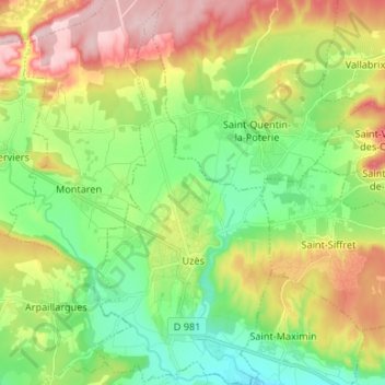
Name: Uzès topographic map, elevation, terrain.

Location: Uzès, Nîmes, Gard, Occitania, Metropolitan France, 30700, France (43.98111 4.38523 44.07659 4.44679)

Average elevation: 135 m

Minimum elevation: 48 m

Maximum elevation: 271 m

Other topographic maps

Click on a map to view its topography, its elevation and its terrain.

Dieusses

France > Occitania > Gard > Chambon

Average elevation: 399 m

Hameau de Besson

France > Occitania > Gard > Bragassargues

Average elevation: 133 m

Russan

France > Occitania > Gard > Sainte-Anastasie

Average elevation: 90 m

Cachar

France > Occitania > Gard > Saint-Jean-du-Gard

Average elevation: 312 m

Les Croisées

France > Occitania > Gard > Castillon-du-Gard

Average elevation: 41 m

La Papeterie

France > Occitania > Gard > Saint-Laurent-le-Minier

Average elevation: 364 m

Gear up for your next adventure:

🧦Thermal Socks - Warm socks for winter hiking or camping
🛌Down Sleeping Bag - Superior warmth-to-weight ratio for cold nights
🦟Insect Repellent - Keep mosquitoes and black flies away in wooded areas
🥾Hiking Shoes - Durable and comfortable shoes for trail hiking
🥾Trekking Poles - Adjustable trekking poles to reduce knee stress and improve stability

As an Amazon Associate, this site earns from qualifying purchases at no extra cost to you.