Geolocate

Meru topographic map

Click on the map to display elevation.

About this map
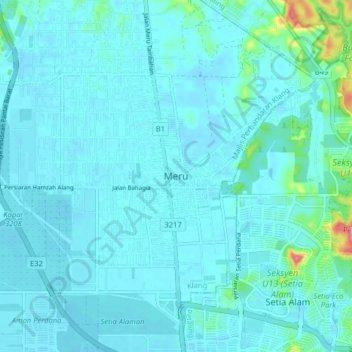
Name: Meru topographic map, elevation, terrain.

Location: Meru, Klang City, Klang, Selangor, 40710, Malaysia (3.09868 101.40113 3.17868 101.48113)

Average elevation: 14 m

Minimum elevation: 2 m

Maximum elevation: 116 m

Other topographic maps

Click on a map to view its topography, its elevation and its terrain.

Indah Island

Malaysia > Selangor > Klang City

Average elevation: 3 m

Bukit Kapar

Malaysia > Selangor > Klang City

Average elevation: 24 m

Pulau Ketam

Malaysia > Selangor > Klang City

Average elevation: 1 m

Indah Island

Malaysia > Selangor > Klang City

Average elevation: 3 m

Indah Island

Malaysia > Selangor > Klang City

Average elevation: 3 m

The Boss

Malaysia > Selangor > Klang City

Average elevation: 9 m

Gear up for your next adventure:

🥾Trail Running Boots - Durable shoes designed for trail running
🔪Outdoor Multitool - Versatile tool for repairs and food prep in the wild
🧼Travel Hand Sanitizer - Keep hands clean when water is scarce
👟Sport Hiking Sandals - Breathable footwear for water crossings and camp rest
🥾All-Terrain Hiking Boots - Versatile boots for varied hiking conditions

As an Amazon Associate, this site earns from qualifying purchases at no extra cost to you.