
Prettingen topographic map
Interactive map
Click on the map to display elevation.
About this map
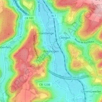
Name: Prettingen topographic map, elevation, terrain.
Location: Prettingen, Lintgen, Canton Mersch, 7460, Luxembourg (49.69702 6.09956 49.73702 6.13956)
Average elevation: 290 m
Minimum elevation: 217 m
Maximum elevation: 409 m
Other topographic maps
Click on a map to view its topography, its elevation and its terrain.
Ernzen
Ernzen, Larochette, Canton Mersch, 7635, Luxembourg
Average elevation: 347 m
Colmar
Luxembourg > Canton Mersch > Colmar
Colmar, Colmar-Berg, Canton Mersch, 7721, Luxembourg
Average elevation: 273 m
Brouch
Luxembourg > Canton Mersch > Helperknapp > Brouch
Brouch, Helperknapp, Canton Mersch, 7416, Luxembourg
Average elevation: 324 m
Lorentzweiler
Lorentzweiler, Canton Mersch, Luxembourg
Average elevation: 323 m
Hollenfels
Luxembourg > Canton Mersch > Helperknapp
Hollenfels, Helperknapp, Canton Mersch, 7435, Luxembourg
Average elevation: 327 m