Geolocate

Gweek topographic map

Click on the map to display elevation.

About this map

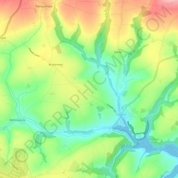
Name: Gweek topographic map, elevation, terrain.

Location: Gweek, Cornwall, England, United Kingdom (50.08367 -5.24607 50.12040 -5.18846)

Average elevation: 59 m

Minimum elevation: 0 m

Maximum elevation: 136 m

Other topographic maps

Click on a map to view its topography, its elevation and its terrain.

Trembraze

United Kingdom > England > Cornwall > Liskeard

Average elevation: 128 m

Freathy

United Kingdom > England > Cornwall

Average elevation: 37 m

Riviere Towans

United Kingdom > England > Cornwall > Hayle > Phillack

Average elevation: 19 m

Pinnacle Gully

United Kingdom > England > Cornwall > Porthgwarra

Average elevation: 19 m

Gear up for your next adventure:

🕯️Camping Lantern - Illuminates your entire campsite with high-efficiency LEDs
🧤Rechargeable Heated Gloves - Extreme warmth for Canadian winter expeditions
🧼Biodegradable Camp Soap - Environmentally friendly cleaning for gear and body
🥾Trekking Boots - Durable boots for long-distance trekking
🧴Insect Repellent - Protect yourself from bugs during outdoor adventures

As an Amazon Associate, this site earns from qualifying purchases at no extra cost to you.