
Cisco topographic map
Interactive map
Click on the map to display elevation.
About this map
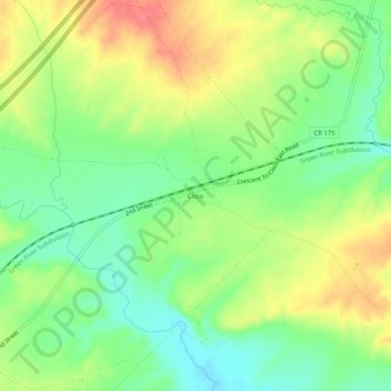
Name: Cisco topographic map, elevation, terrain.
Location: Cisco, Grand County, Utah, 84515, United States (38.94999 -109.34067 38.98999 -109.30067)
Average elevation: 1,334 m
Minimum elevation: 1,305 m
Maximum elevation: 1,369 m
Other topographic maps
Click on a map to view its topography, its elevation and its terrain.
Moab
United States > Utah > Grand County
Moab, Grand County, Utah, 84532, United States
Average elevation: 1,357 m
Westwater
United States > Utah > Grand County
Westwater, Grand County, Utah, United States
Average elevation: 1,349 m
Rectory
United States > Utah > Grand County
Rectory, Grand County, Utah, United States
Average elevation: 1,527 m
Delicate Arch
United States > Utah > Grand County
Delicate Arch, Delicate Arch Trail, Grand County, Utah, United States
Average elevation: 1,409 m
Thompson Springs
United States > Utah > Grand County
Thompson Springs, Grand County, Utah, 84540, United States
Average elevation: 1,583 m
Arches National Park
United States > Utah > Grand County
Arches National Park, Grand County, Utah, United States
Average elevation: 1,476 m
Colorado River
United States > Utah > Grand County > Moab
Colorado River, Moab, Grand County, Utah, United States
Average elevation: 1,668 m
Castle Valley
United States > Utah > Grand County
Castle Valley, Grand County, Utah, United States
Average elevation: 1,610 m
Cottonwood Point
United States > Utah > Grand County
Cottonwood Point, Grand County, Utah, United States
Average elevation: 2,346 m
La Sal Mountains Viewpoint
United States > Utah > Grand County
La Sal Mountains Viewpoint, Main Park Road, Grand County, Utah, 84532-2134, United States
Average elevation: 1,347 m