Geolocate

Castle Valley topographic map

Click on the map to display elevation.

About this map

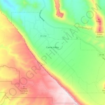
Name: Castle Valley topographic map, elevation, terrain.

Location: Castle Valley, Grand County, Utah, United States (38.60833 -109.44475 38.66322 -109.35336)

Average elevation: 1,610 m

Minimum elevation: 1,265 m

Maximum elevation: 2,067 m

Other topographic maps

Click on a map to view its topography, its elevation and its terrain.

Tenmile Point

United States > Utah > Grand County

Average elevation: 1,347 m

Westwater

United States > Utah > Grand County

Average elevation: 1,349 m

Castleton Tower

United States > Utah > Grand County

Average elevation: 1,549 m

Manns Peak

United States > Utah > Grand County

Average elevation: 3,427 m

Gear up for your next adventure:

🪑Insulated Seat Pad - Protect your seat from cold rocks and wet logs
👖Convertible Hiking Pants - Zip-off legs to adapt to changing weather conditions
🕶️Polarized Sunglasses - Reduces glare from snow and water at high elevations
🧊Portable Cooler - Keep food and drinks cold during outdoor adventures
🥾Mountain Hiking Boots - High-traction boots for rocky terrain

As an Amazon Associate, this site earns from qualifying purchases at no extra cost to you.