Geolocate

Pampas topographic map

Click on the map to display elevation.

About this map

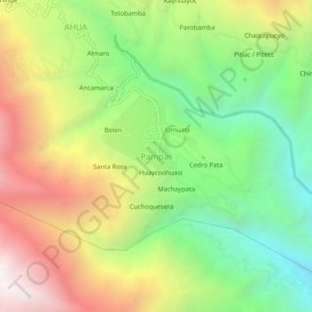
Name: Pampas topographic map, elevation, terrain.

Location: Pampas, Luis Carranza, Province of La Mar, Ayacucho, Peru (-13.24890 -73.91428 -13.20890 -73.87428)

Average elevation: 3,067 m

Minimum elevation: 2,295 m

Maximum elevation: 4,060 m

Gear up for your next adventure:

💧Filtered Water Bottle - Safe drinking water on the go
💡Solar Camping Lamp - Eco-friendly lighting for campsites
🛶Canoe Life Vest - Safety vest for water sports
🧊Portable Cooler - Keep food and drinks cold during outdoor adventures
💧Reusable Water Bottle - Durable water bottles for hydration on trails

As an Amazon Associate, this site earns from qualifying purchases at no extra cost to you.