Geolocate

St Leonards topographic map

Click on the map to display elevation.

About this map
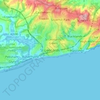
Name: St Leonards topographic map, elevation, terrain.

Location: St Leonards, Hastings, East Sussex, England, TN38 0NY, United Kingdom (50.81573 0.50801 50.89573 0.58801)

Average elevation: 31 m

Minimum elevation: -1 m

Maximum elevation: 155 m

Other topographic maps

Click on a map to view its topography, its elevation and its terrain.

Lewes Castle

United Kingdom > England > East Sussex > Lewes

Average elevation: 26 m

Wadhurst

United Kingdom > England > East Sussex > Wealden

Average elevation: 109 m

Ticehurst

United Kingdom > England > East Sussex > Rother

Average elevation: 81 m

Frant

United Kingdom > England > East Sussex > Wealden > Bells Yew Green

Average elevation: 111 m

Crowborough

United Kingdom > England > East Sussex > Wealden

In the late 19th century, Crowborough was promoted as a health resort based on its high elevation, the rolling hills and surrounding forest. Estate Agents even called it "Scotland in Sussex". The town's golf course opened in 1895, followed by a fire station and hospital in 1900.

Average elevation: 146 m

Battle

United Kingdom > England > East Sussex > Rother > Battle

Average elevation: 66 m

Gear up for your next adventure:

🔋Lithium AA Batteries - Long-lasting power that performs in extreme cold
🕶️Polarized Sunglasses - Protect your eyes with durable polarized lenses
🛌Down Sleeping Bag - Superior warmth-to-weight ratio for cold nights
🧢Hiking Hat - Sun-protective and breathable hats for long treks
🔨Vehicle Emergency Tool - Safety tool for remote road trips to trailheads

As an Amazon Associate, this site earns from qualifying purchases at no extra cost to you.