Geolocate

Yankin topographic map

Click on the map to display elevation.

About this map

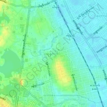
Name: Yankin topographic map, elevation, terrain.

Location: Yankin, Thingangyun District, Yangon City, Yangon, 11081, Myanmar (16.82307 96.15465 16.85199 96.17803)

Average elevation: 14 m

Minimum elevation: 6 m

Maximum elevation: 30 m

Other topographic maps

Click on a map to view its topography, its elevation and its terrain.

Htauk Kyant

Myanmar > Yangon > Yangon City

Average elevation: 17 m

Zee Kone

Myanmar > Yangon > Yangon City

Average elevation: 11 m

Gear up for your next adventure:

🔨Vehicle Emergency Tool - Safety tool for remote road trips to trailheads
🧥Fleece Jacket - Warm and lightweight jacket for layering
🥾Mountain Trail Shoes - High-traction shoes for mountain trails
🧦Merino Wool Socks - Moisture-wicking comfort for long-distance hiking
🧥Ultralight Puffy Jacket - Maximum warmth that packs down to the size of an orange

As an Amazon Associate, this site earns from qualifying purchases at no extra cost to you.