
Make a donation
Gear up for your next adventure:
As an Amazon Associate, this site earns from qualifying purchases at no extra cost to you.
Magallanes topographic map
Click on the map to display elevation.
Make a donation
Gear up for your next adventure:
As an Amazon Associate, this site earns from qualifying purchases at no extra cost to you.
Magallanes
The topography of the land is mostly flat and rolling, surrounded by mountains. Swamps characterize much of the landscape that is situated at the mouth of the two major rivers in the province, the Agusan and Baug Rivers.
Make a donation
Gear up for your next adventure:
As an Amazon Associate, this site earns from qualifying purchases at no extra cost to you.
About this map
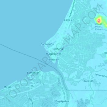
Name: Magallanes topographic map, elevation, terrain.
Location: Magallanes, Agusan del Norte, Caraga, 8604, Philippines (8.98371 125.47851 9.06371 125.55851)
Average elevation: 3 m
Minimum elevation: 0 m
Maximum elevation: 136 m
Make a donation
Gear up for your next adventure:
As an Amazon Associate, this site earns from qualifying purchases at no extra cost to you.
Other topographic maps
Click on a map to view its topography, its elevation and its terrain.
Make a donation
Gear up for your next adventure:
As an Amazon Associate, this site earns from qualifying purchases at no extra cost to you.