Geolocate

Carmen topographic map

Click on the map to display elevation.

About this map

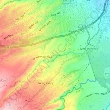
Name: Carmen topographic map, elevation, terrain.

Location: Carmen, Silang, Cavite, Calabarzon, 4118, Philippines (14.20608 121.01529 14.24608 121.05529)

Average elevation: 190 m

Minimum elevation: 93 m

Maximum elevation: 299 m

Other topographic maps

Click on a map to view its topography, its elevation and its terrain.

Carmen

Philippines > Cavite > Silang

Average elevation: 172 m

Carmen

Philippines > Cavite > Silang

Average elevation: 172 m

Gear up for your next adventure:

🥾Trail Hiking Boots - Supportive boots for rough trails
🧥Insulated Jacket - Keep warm in cold outdoor conditions
💧Hydration Pack - Hands-free hydration system for long hikes
🥾Hiking Leggings - Comfortable leggings for outdoor activities
🛶Canoe Life Vest - Safety vest for water sports

As an Amazon Associate, this site earns from qualifying purchases at no extra cost to you.