Geolocate

Maudsland topographic map

Click on the map to display elevation.

About this map
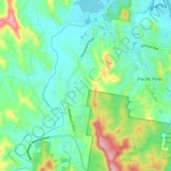
Name: Maudsland topographic map, elevation, terrain.

Location: Maudsland, Gold Coast, Queensland, Australia (-27.97577 153.25967 -27.90603 153.30380)

Average elevation: 64 m

Minimum elevation: 3 m

Maximum elevation: 230 m

Other topographic maps

Click on a map to view its topography, its elevation and its terrain.

Clagiraba

Australia > Queensland > Gold Coast

Average elevation: 122 m

Binna Burra

Australia > Queensland > Gold Coast

Average elevation: 535 m

Pimpama

Australia > Queensland > Gold Coast > Pimpama

Average elevation: 19 m

Reedy Creek

Australia > Queensland > Gold Coast

Average elevation: 16 m

Maudsland

Australia > Queensland > Gold Coast

Average elevation: 43 m

Lower Beechmont

Australia > Queensland > Gold Coast

Average elevation: 297 m

Guanaba

Australia > Queensland > Gold Coast

Average elevation: 51 m

Austinville

Australia > Queensland > Gold Coast

Average elevation: 146 m

Anglers Paradise

Australia > Queensland > Gold Coast

Average elevation: 2 m

Gear up for your next adventure:

🧢Beanie Hat - Keep your head warm in cold weather
🧳Compression Sacks - Maximize space in your backpack by shrinking gear
💡Portable Camping Lamp - Rechargeable lamp for campsite lighting
🛏️Sleeping Bag - Warm and compact sleeping bags for outdoor camping
🧭GPS Outdoor Watch - Smart watch for navigation and fitness tracking in nature

As an Amazon Associate, this site earns from qualifying purchases at no extra cost to you.