Geolocate

Titsey topographic map

Click on the map to display elevation.

About this map

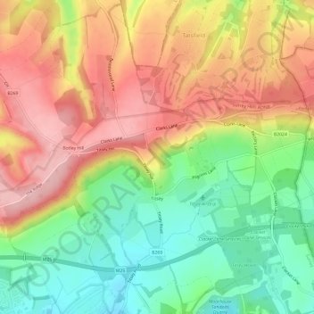
Name: Titsey topographic map, elevation, terrain.

Location: Titsey, Limpsfield, Tandridge, Surrey, England, United Kingdom (51.26238 -0.01728 51.29960 0.04088)

Average elevation: 185 m

Minimum elevation: 100 m

Maximum elevation: 271 m

Gear up for your next adventure:

🦶Anti-Blister Balm - Prevents friction and hotspots during long ascents
🧥Waterproof Jacket - Lightweight rain jackets for hiking and outdoor activities
🥾Hiking Gaiters - Protect legs and shoes from mud, snow, and debris
🔭Compact Binoculars - Lightweight optics for scouting trails and wildlife
Backpacking Tent - Lightweight tent for long-distance hiking trips

As an Amazon Associate, this site earns from qualifying purchases at no extra cost to you.