Geolocate

Madehurst topographic map

Click on the map to display elevation.

About this map

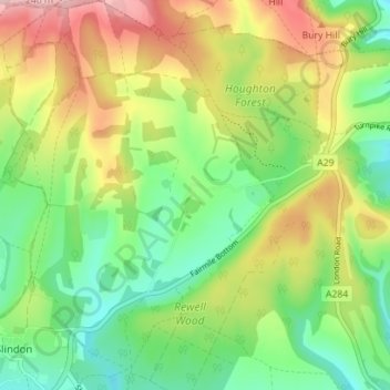
Name: Madehurst topographic map, elevation, terrain.

Location: Madehurst, Arun, West Sussex, England, United Kingdom (50.86133 -0.62393 50.90557 -0.58449)

Average elevation: 96 m

Minimum elevation: 19 m

Maximum elevation: 208 m

Other topographic maps

Click on a map to view its topography, its elevation and its terrain.

Bognor Regis

United Kingdom > England > West Sussex > Arun > Nyetimber

Average elevation: 2 m

Nyetimber

United Kingdom > England > West Sussex > Arun

Average elevation: 3 m

Lidsey Rife

United Kingdom > England > West Sussex > Arun > Felpham

Average elevation: 3 m

Elmer

United Kingdom > England > West Sussex > Arun

Average elevation: 2 m

Wick

United Kingdom > England > West Sussex > Arun > Littlehampton > Lyminster

Average elevation: 3 m

Shripney

United Kingdom > England > West Sussex > Arun

Average elevation: 3 m

Fontwell

United Kingdom > England > West Sussex > Arun

Average elevation: 31 m

Eastergate

United Kingdom > England > West Sussex > Arun

Average elevation: 12 m

Barnham

United Kingdom > England > West Sussex > Arun

Average elevation: 6 m

North Bersted

United Kingdom > England > West Sussex > Arun

Average elevation: 3 m

Binsted

United Kingdom > England > West Sussex > Arun > Walberton

Average elevation: 23 m

Barnham

United Kingdom > England > West Sussex > Arun

Average elevation: 6 m

Eastergate

United Kingdom > England > West Sussex > Arun

Average elevation: 12 m

Gear up for your next adventure:

🪜Heavy Duty Carabiners - Multi-use clips for securing gear to your backpack
🧼Travel Hand Sanitizer - Keep hands clean when water is scarce
🛶Canoe Life Vest - Safety vest for water sports
🚲Heavy Duty Bike Lock - Secure your bike at the trailhead or during stops
🧭GPS Tracker - Track your location in remote areas safely

As an Amazon Associate, this site earns from qualifying purchases at no extra cost to you.