
Toberbeg topographic map
Interactive map
Click on the map to display elevation.
About this map
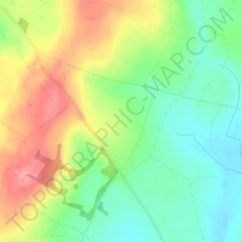
Name: Toberbeg topographic map, elevation, terrain.
Average elevation: 207 m
Minimum elevation: 166 m
Maximum elevation: 262 m
Other topographic maps
Click on a map to view its topography, its elevation and its terrain.
Roundwood
Roundwood, The Municipal District of Wicklow, County Wicklow, Leinster, Ireland
Average elevation: 242 m
Rathmichael (Bray) ED
Rathmichael (Bray) ED, The Municipal District of Bray, County Wicklow, Leinster, Ireland
Average elevation: 36 m
Aughrim
Aughrim, The Municipal District of Arklow, County Wicklow, Leinster, Y14 HT72, Ireland
Average elevation: 123 m