
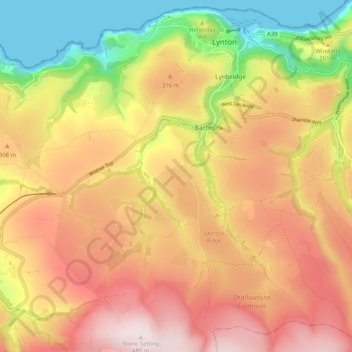
Lynton and Lynmouth topographic map
Interactive map
Click on the map to display elevation.
About this map
Name: Lynton and Lynmouth topographic map, elevation, terrain.
Average elevation: 260 m
Minimum elevation: 0 m
Maximum elevation: 477 m
Other topographic maps
Click on a map to view its topography, its elevation and its terrain.
Ilfracombe
United Kingdom > England > North Devon > Ilfracombe
Ilfracombe, Devon, South West England, England, EX34 9, United Kingdom
Average elevation: 78 m
Barnstaple
United Kingdom > England > North Devon > Barnstaple
Barnstaple, Devon, South West England, England, EX31 1BN, United Kingdom
Average elevation: 69 m
North Molton
United Kingdom > England > North Devon > North Molton
North Molton, North Devon, Devon, South West England, England, EX36 3HP, United Kingdom
Average elevation: 203 m
Combe Martin
United Kingdom > England > North Devon > Combe Martin
Combe Martin, North Devon, Devon, South West England, England, United Kingdom
Average elevation: 100 m
Chittlehampton
United Kingdom > England > North Devon > Chittlehampton
Chittlehampton, North Devon, Devon, South West England, England, United Kingdom
Average elevation: 104 m
Lee
United Kingdom > England > North Devon > Lee
Lee, North Devon, Devon, South West England, England, EX34 8LR, United Kingdom
Average elevation: 84 m
Mariansleigh
United Kingdom > England > North Devon > Mariansleigh
Mariansleigh, North Devon, Devon, South West England, England, United Kingdom
Average elevation: 144 m
Swimbridge
United Kingdom > England > North Devon > Swimbridge
Swimbridge, North Devon, Devon, South West England, England, United Kingdom
Average elevation: 126 m
Eastacombe
United Kingdom > England > North Devon > Eastacombe
Eastacombe, North Devon, Devon, South West England, England, EX31 3NU, United Kingdom
Average elevation: 70 m
Goodleigh
United Kingdom > England > North Devon > Goodleigh
Goodleigh, North Devon, Devon, South West England, England, EX32 7LX, United Kingdom
Average elevation: 111 m
Gunn
United Kingdom > England > North Devon > Gunn
Gunn, Goodleigh, North Devon, Devon, South West England, England, EX32 7PG, United Kingdom
Average elevation: 181 m
Swimbridge
United Kingdom > England > North Devon > Swimbridge
Swimbridge, North Devon, Devon, South West England, England, EX32 0PG, United Kingdom
Average elevation: 113 m
Fremington
United Kingdom > England > North Devon > Fremington
Fremington, North Devon, Devon, South West England, England, EX31 3BX, United Kingdom
Average elevation: 30 m
Codden Hill
United Kingdom > England > North Devon
Codden Hill, North Devon, Devon, South West England, England, EX32 0BU, United Kingdom
Average elevation: 66 m
Mortehoe
United Kingdom > England > North Devon
Mortehoe, North Devon, Devon, South West England, England, United Kingdom
Average elevation: 98 m
Croyde Bay
United Kingdom > England > North Devon
Croyde Bay, Moor Lane, Georgeham, North Devon, Devon, South West England, England, EX33 1PA, United Kingdom
Average elevation: 17 m
Bratton Fleming
United Kingdom > England > North Devon > Bratton Fleming
Bratton Fleming, Devon, South West England, England, EX31 4SA, United Kingdom
Average elevation: 216 m
Braunton Burrows
United Kingdom > England > North Devon
Braunton Burrows, American Road, Braunton, North Devon, Devon, South West England, England, EX33 2NX, United Kingdom
Average elevation: 6 m
Saunton Sands
United Kingdom > England > North Devon
Saunton Sands, Saunton Road, Braunton, North Devon, Devon, South West England, England, EX33 1FG, United Kingdom
Average elevation: 4 m
Badgworthy Water
United Kingdom > England > North Devon
Badgworthy Water, North Devon, Devon, South West England, England, EX35 6NU, United Kingdom
Average elevation: 356 m
Little Dart River
United Kingdom > England > North Devon
Little Dart River, North Devon, Devon, South West England, England, EX16 8DR, United Kingdom
Average elevation: 227 m
Treyhill Moor Plantation
United Kingdom > England > North Devon
Treyhill Moor Plantation, Atlantic Highway, Westleigh, North Devon, Devon, South West England, England, EX39 4LS, United Kingdom
Average elevation: 76 m
East Lyn
United Kingdom > England > North Devon
East Lyn, North Devon, Devon, South West England, England, EX35 6EH, United Kingdom
Average elevation: 129 m
Fremington Quay
United Kingdom > England > North Devon
Fremington Quay, North Devon, Devon, South West England, England, EX31 2NH, United Kingdom
Average elevation: 9 m
River Caen
United Kingdom > England > North Devon
River Caen, North Devon, Devon, South West England, England, EX34 8NJ, United Kingdom
Average elevation: 192 m
River Bray
United Kingdom > England > North Devon
River Bray, North Devon, Devon, South West England, England, EX31 4TT, United Kingdom
Average elevation: 325 m
Combesgate Beach
United Kingdom > England > North Devon
Combesgate Beach, The Esplanade, Mortehoe, North Devon, Devon, South West England, England, EX34 7DL, United Kingdom
Average elevation: 52 m
River Heddon
United Kingdom > England > North Devon
River Heddon, North Devon, Devon, South West England, England, EX31 4PZ, United Kingdom
Average elevation: 106 m
Heanton Punchardon
United Kingdom > England > North Devon
Heanton Punchardon, North Devon, Devon, South West England, England, United Kingdom
Average elevation: 35 m
Satterleigh and Warkleigh
United Kingdom > England > North Devon
Satterleigh and Warkleigh, North Devon, Devon, South West England, England, United Kingdom
Average elevation: 107 m