Geolocate

Changanassery topographic map

Click on the map to display elevation.

About this map

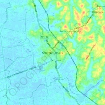
Name: Changanassery topographic map, elevation, terrain.

Location: Changanassery, Kottayam, Kerala, 686101, India (9.40322 76.50118 9.48322 76.58118)

Average elevation: 8 m

Minimum elevation: -5 m

Maximum elevation: 40 m

Other topographic maps

Click on a map to view its topography, its elevation and its terrain.

Kurichy

India > Kerala > Changanassery > Putuppalli

Average elevation: 11 m

Mammoodu

India > Kerala > Changanassery > Mammood

Average elevation: 31 m

Cheeranchira

India > Kerala > Changanassery > Kurishummoodu

Average elevation: 18 m

Thrikkodithanam

India > Kerala > Changanassery > Valiyakulam

Average elevation: 22 m

Gear up for your next adventure:

🥫Freeze-Dried Meals - Lightweight, high-calorie nutrition for multi-day treks
Camping Tent - Weather-resistant tents suitable for 2 to 6 people
🥾Trail Hiking Socks - Comfortable socks to prevent blisters and fatigue
🧶550 Survival Paracord - Versatile utility cord for emergency repairs and rigging
🧥Insulated Jacket - Keep warm in cold outdoor conditions

As an Amazon Associate, this site earns from qualifying purchases at no extra cost to you.