
Make a donation
Gear up for your next adventure:
As an Amazon Associate, this site earns from qualifying purchases at no extra cost to you.
Cederberg topographic map
Click on the map to display elevation.
Make a donation
Gear up for your next adventure:
As an Amazon Associate, this site earns from qualifying purchases at no extra cost to you.
About this map
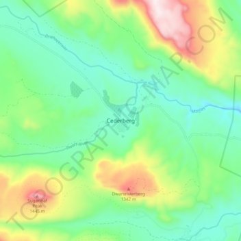
Name: Cederberg topographic map, elevation, terrain.
Average elevation: 997 m
Minimum elevation: 769 m
Maximum elevation: 1,502 m
Make a donation
Gear up for your next adventure:
As an Amazon Associate, this site earns from qualifying purchases at no extra cost to you.
Other topographic maps
Click on a map to view its topography, its elevation and its terrain.
Swartland Local Municipality
South Africa > Western Cape > West Coast District Municipality
Average elevation: 115 m
Malmesbury
South Africa > Western Cape > West Coast District Municipality > Swartland Local Municipality
Average elevation: 171 m
Bulshoek Dam
South Africa > Western Cape > West Coast District Municipality > Cederberg Local Municipality
Average elevation: 184 m
Matzikama Ward 8
South Africa > Western Cape > West Coast District Municipality > Matzikama Local Municipality
Average elevation: 332 m
Make a donation
Gear up for your next adventure:
As an Amazon Associate, this site earns from qualifying purchases at no extra cost to you.
Darling Wildflower Nature Reserve
South Africa > Western Cape > West Coast District Municipality > Swartland Local Municipality > Darling
Average elevation: 148 m
Saldanha Bay Local Municipality
South Africa > Western Cape > West Coast District Municipality
Average elevation: 60 m
Cederberg Local Municipality
South Africa > Western Cape > West Coast District Municipality
Average elevation: 427 m
Matzikama Local Municipality
South Africa > Western Cape > West Coast District Municipality
Average elevation: 309 m
Make a donation
Gear up for your next adventure:
As an Amazon Associate, this site earns from qualifying purchases at no extra cost to you.
Cederberg Ward 1
South Africa > Western Cape > West Coast District Municipality > Cederberg Local Municipality
Average elevation: 690 m
West Coast National Park
South Africa > Western Cape > West Coast District Municipality
Average elevation: 46 m
Bergrivier Local Municipality
South Africa > Western Cape > West Coast District Municipality
Average elevation: 180 m
Clanwilliam Dam
South Africa > Western Cape > West Coast District Municipality > Cederberg Local Municipality > Clanwilliam
Average elevation: 289 m
Make a donation
Gear up for your next adventure:
As an Amazon Associate, this site earns from qualifying purchases at no extra cost to you.
Dassen Island
South Africa > Western Cape > West Coast District Municipality > Swartland Local Municipality
Average elevation: 2 m
Cederberg Local Municipality
South Africa > Western Cape > West Coast District Municipality
Average elevation: 427 m
Cederberg Local Municipality
South Africa > Western Cape > West Coast District Municipality
Average elevation: 427 m
Cape Floral Region Protected Areas
South Africa > Western Cape > West Coast District Municipality
Average elevation: 337 m
Make a donation
Gear up for your next adventure:
As an Amazon Associate, this site earns from qualifying purchases at no extra cost to you.
Saldanha Bay Ward 6
South Africa > Western Cape > West Coast District Municipality > Saldanha Bay Local Municipality
Average elevation: 53 m
Krom
South Africa > Western Cape > West Coast District Municipality > Cederberg Local Municipality
Average elevation: 870 m
Darling Wildflower Nature Reserve
South Africa > Western Cape > West Coast District Municipality > Swartland Local Municipality > Darling
Average elevation: 148 m
Dassen Island
South Africa > Western Cape > West Coast District Municipality > Swartland Local Municipality
Average elevation: 2 m
Make a donation
Gear up for your next adventure:
As an Amazon Associate, this site earns from qualifying purchases at no extra cost to you.
Malmesbury
South Africa > Western Cape > West Coast District Municipality > Swartland Local Municipality
Average elevation: 171 m
Cederberg Local Municipality
South Africa > Western Cape > West Coast District Municipality
Average elevation: 427 m
Matzikama Local Municipality
South Africa > Western Cape > West Coast District Municipality
Average elevation: 309 m
Die Hel
South Africa > Western Cape > West Coast District Municipality > Bergrivier Local Municipality
Average elevation: 621 m
Make a donation
Gear up for your next adventure:
As an Amazon Associate, this site earns from qualifying purchases at no extra cost to you.
Cederberg Local Municipality
South Africa > Western Cape > West Coast District Municipality
Average elevation: 427 m