
Make a donation
Gear up for your next adventure:
As an Amazon Associate, this site earns from qualifying purchases at no extra cost to you.
Cederberg Local Municipality topographic map
Click on the map to display elevation.
Make a donation
Gear up for your next adventure:
As an Amazon Associate, this site earns from qualifying purchases at no extra cost to you.
About this map
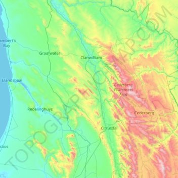
Name: Cederberg Local Municipality topographic map, elevation, terrain.
Average elevation: 427 m
Minimum elevation: -1 m
Maximum elevation: 2,050 m
Make a donation
Gear up for your next adventure:
As an Amazon Associate, this site earns from qualifying purchases at no extra cost to you.
Other topographic maps
Click on a map to view its topography, its elevation and its terrain.
Citrusdal
South Africa > Western Cape > West Coast District Municipality > Cederberg Local Municipality
Average elevation: 256 m
Clanwilliam
South Africa > Western Cape > West Coast District Municipality > Cederberg Local Municipality
Clanwilliam is situated at an elevation of 100 metres (330 ft), between the western slopes of the Cederberg mountains and the east bank of the Olifants River, which is impounded there by the Clanwilliam Dam. It is located just off the N7 national road, which runs from Cape Town to the Namibian border, and on…
Average elevation: 162 m
Riebeek-Kasteel
South Africa > Western Cape > West Coast District Municipality > Swartland Local Municipality
Average elevation: 186 m
Vredendal
South Africa > Western Cape > West Coast District Municipality > Matzikama Local Municipality
Average elevation: 51 m
Make a donation
Gear up for your next adventure:
As an Amazon Associate, this site earns from qualifying purchases at no extra cost to you.
Vredenburg
South Africa > Western Cape > West Coast District Municipality > Saldanha Bay Local Municipality
Average elevation: 91 m
Saldanha
South Africa > Western Cape > West Coast District Municipality > Saldanha Bay Local Municipality
Average elevation: 27 m
Langebaan
South Africa > Western Cape > West Coast District Municipality > Saldanha Bay Local Municipality
Average elevation: 34 m
Yzerfontein
South Africa > Western Cape > West Coast District Municipality > Swartland Local Municipality
Average elevation: 8 m
Make a donation
Gear up for your next adventure:
As an Amazon Associate, this site earns from qualifying purchases at no extra cost to you.
Piketberg
South Africa > Western Cape > West Coast District Municipality > Bergrivier Local Municipality
Average elevation: 265 m
Vanrhynsdorp
South Africa > Western Cape > West Coast District Municipality > Matzikama Local Municipality
Average elevation: 139 m
Wolfberg Arch
South Africa > Western Cape > West Coast District Municipality > Cederberg Local Municipality > Cederberg
Average elevation: 1,413 m
Klawer
South Africa > Western Cape > West Coast District Municipality > Matzikama Local Municipality
Average elevation: 142 m
Make a donation
Gear up for your next adventure:
As an Amazon Associate, this site earns from qualifying purchases at no extra cost to you.
Saint Helena Bay
South Africa > Western Cape > West Coast District Municipality > Saldanha Bay Local Municipality
Average elevation: 45 m
Bulshoek Dam
South Africa > Western Cape > West Coast District Municipality > Cederberg Local Municipality
Average elevation: 184 m
Koekenaap
South Africa > Western Cape > West Coast District Municipality > Matzikama Local Municipality
Average elevation: 46 m
Make a donation
Gear up for your next adventure:
As an Amazon Associate, this site earns from qualifying purchases at no extra cost to you.
Elandsbaai
South Africa > Western Cape > West Coast District Municipality > Cederberg Local Municipality
Average elevation: 43 m
Darling
South Africa > Western Cape > West Coast District Municipality > Swartland Local Municipality
Average elevation: 156 m
Redelinghuys
South Africa > Western Cape > West Coast District Municipality > Bergrivier Local Municipality
Average elevation: 106 m
Darling Wildflower Nature Reserve
South Africa > Western Cape > West Coast District Municipality > Swartland Local Municipality > Darling
Average elevation: 148 m
Make a donation
Gear up for your next adventure:
As an Amazon Associate, this site earns from qualifying purchases at no extra cost to you.
Strandfontein
South Africa > Western Cape > West Coast District Municipality > Matzikama Local Municipality
Average elevation: 36 m
Hopefield
South Africa > Western Cape > West Coast District Municipality > Saldanha Bay Local Municipality
Average elevation: 58 m
Lambert's Bay
South Africa > Western Cape > West Coast District Municipality > Cederberg Local Municipality
Average elevation: 19 m
Kalbaskraal
South Africa > Western Cape > West Coast District Municipality > Swartland Local Municipality
Average elevation: 75 m
Make a donation
Gear up for your next adventure:
As an Amazon Associate, this site earns from qualifying purchases at no extra cost to you.
Moorreesburg
South Africa > Western Cape > West Coast District Municipality > Swartland Local Municipality
Average elevation: 172 m
Tafelberg
South Africa > Western Cape > West Coast District Municipality > Cederberg Local Municipality
Average elevation: 1,526 m
Sneeuberg
South Africa > Western Cape > West Coast District Municipality > Cederberg Local Municipality
Average elevation: 1,542 m
Dassen Island
South Africa > Western Cape > West Coast District Municipality > Swartland Local Municipality
Average elevation: 2 m
Make a donation
Gear up for your next adventure:
As an Amazon Associate, this site earns from qualifying purchases at no extra cost to you.
Porterville
South Africa > Western Cape > West Coast District Municipality > Bergrivier Local Municipality
Average elevation: 207 m
Saldanha
South Africa > Western Cape > West Coast District Municipality > Saldanha Bay Local Municipality
Average elevation: 27 m
Velddrif
South Africa > Western Cape > West Coast District Municipality > Bergrivier Local Municipality > Velddrif
Average elevation: 8 m
Aurora
South Africa > Western Cape > West Coast District Municipality > Bergrivier Local Municipality
Average elevation: 136 m
Make a donation
Gear up for your next adventure:
As an Amazon Associate, this site earns from qualifying purchases at no extra cost to you.
Hopefield
South Africa > Western Cape > West Coast District Municipality > Saldanha Bay Local Municipality
Average elevation: 58 m
Vredenburg
South Africa > Western Cape > West Coast District Municipality > Saldanha Bay Local Municipality
Average elevation: 91 m
Velddrif
South Africa > Western Cape > West Coast District Municipality > Bergrivier Local Municipality
Average elevation: 8 m
Redelinghuys
South Africa > Western Cape > West Coast District Municipality > Bergrivier Local Municipality
Average elevation: 106 m
Make a donation
Gear up for your next adventure:
As an Amazon Associate, this site earns from qualifying purchases at no extra cost to you.
Uitkyk
South Africa > Western Cape > West Coast District Municipality > Matzikama Local Municipality
Average elevation: 54 m
Vredendal
South Africa > Western Cape > West Coast District Municipality > Matzikama Local Municipality
Average elevation: 51 m
Krom
South Africa > Western Cape > West Coast District Municipality > Cederberg Local Municipality
Average elevation: 870 m
Clanwilliam
South Africa > Western Cape > West Coast District Municipality > Cederberg Local Municipality
Clanwilliam is situated at an elevation of 100 metres (330 ft), between the western slopes of the Cederberg mountains and the east bank of the Olifants River, which is impounded there by the Clanwilliam Dam. It lies just off the N7 national road, which runs from Cape Town to the Namibian border, and on the…
Average elevation: 162 m
Make a donation
Gear up for your next adventure:
As an Amazon Associate, this site earns from qualifying purchases at no extra cost to you.
Piketberg
South Africa > Western Cape > West Coast District Municipality > Bergrivier Local Municipality
Average elevation: 265 m
Koekenaap
South Africa > Western Cape > West Coast District Municipality > Matzikama Local Municipality
Average elevation: 46 m
Darling Wildflower Nature Reserve
South Africa > Western Cape > West Coast District Municipality > Swartland Local Municipality > Darling
Average elevation: 148 m
Dassen Island
South Africa > Western Cape > West Coast District Municipality > Swartland Local Municipality
Average elevation: 2 m
Make a donation
Gear up for your next adventure:
As an Amazon Associate, this site earns from qualifying purchases at no extra cost to you.
Paternoster
South Africa > Western Cape > West Coast District Municipality > Saldanha Bay Local Municipality
Average elevation: 20 m
Langebaan
South Africa > Western Cape > West Coast District Municipality > Saldanha Bay Local Municipality
Average elevation: 34 m
Die Hel
South Africa > Western Cape > West Coast District Municipality > Bergrivier Local Municipality
Average elevation: 621 m
Graafwater
South Africa > Western Cape > West Coast District Municipality > Cederberg Local Municipality
Average elevation: 197 m
Make a donation
Gear up for your next adventure:
As an Amazon Associate, this site earns from qualifying purchases at no extra cost to you.