Geolocate

Gyalshing topographic map

Click on the map to display elevation.

About this map

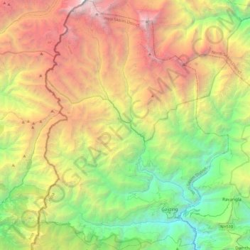
Name: Gyalshing topographic map, elevation, terrain.

Location: Gyalshing, West Sikkim District, Sikkim, India (27.22731 88.03013 27.60977 88.35827)

Average elevation: 3,139 m

Minimum elevation: 481 m

Maximum elevation: 7,257 m

Other topographic maps

Click on a map to view its topography, its elevation and its terrain.

Sangkalang

India > Sikkim > Mangan

Average elevation: 1,166 m

Siniolchu

India > Sikkim > Chungthang

Average elevation: 5,890 m

Dzongri

India > Sikkim > Gyalshing

Average elevation: 3,859 m

Kupup

India > Sikkim

Average elevation: 4,007 m

Danfebir

India > Sikkim > Gyalshing

Average elevation: 4,330 m

Phong

India > Sikkim > Namchi

Average elevation: 1,298 m

Pelling

India > Sikkim > Gyalshing > Pelling

Average elevation: 1,552 m

East District

India > Sikkim > East District

Average elevation: 2,740 m

West District

India > Sikkim

Average elevation: 2,636 m

Gear up for your next adventure:

🧴Insect Repellent - Protect yourself from bugs during outdoor adventures
💡LED Camping Lantern - Illuminate your campsite with long-lasting lanterns
🦶Anti-Blister Balm - Prevents friction and hotspots during long ascents
🔦UV Flashlight - Detect minerals or specific insects in the dark
Bushcraft Tarp - Versatile emergency shelter or gear protection

As an Amazon Associate, this site earns from qualifying purchases at no extra cost to you.