Geolocate

Zekri topographic map

Click on the map to display elevation.

About this map
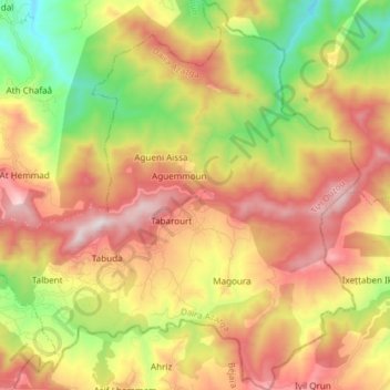
Name: Zekri topographic map, elevation, terrain.

Location: Zekri, Azazga District, Tizi Ouzou, 15000, Algeria (36.73023 4.50567 36.85019 4.65296)

Average elevation: 585 m

Minimum elevation: 62 m

Maximum elevation: 1,129 m

Other topographic maps

Click on a map to view its topography, its elevation and its terrain.
Tamda

Algeria > Tizi Ouzou > Azazga District > Freha

Average elevation: 139 m

Gear up for your next adventure:

🎒Fully Waterproof Backpack - Total protection for photography gear and electronics
🛶Kayak Accessories - Essential gear for safe and fun kayaking adventures
🧢Outdoor Cap - Protective cap for sun and rain during hikes
🧦Outdoor Socks - Durable socks designed for hiking and outdoor sports
🥤Collapsible Travel Cup - Saves space and weight in your mess kit

As an Amazon Associate, this site earns from qualifying purchases at no extra cost to you.