Geolocate

Feni District topographic map

Click on the map to display elevation.

About this map

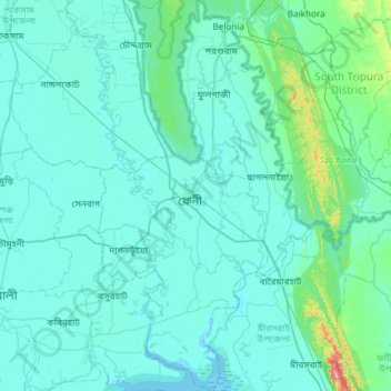
Name: Feni District topographic map, elevation, terrain.

Location: Feni District, Chattogram Division, Bangladesh (22.73813 91.24957 23.28665 91.58487)

Average elevation: 19 m

Minimum elevation: -2 m

Maximum elevation: 263 m

Other topographic maps

Click on a map to view its topography, its elevation and its terrain.

Hatiya

Bangladesh > Chattogram Division

Average elevation: 3 m

Gear up for your next adventure:

🦌Outdoor Trail Camera - Monitor wildlife activity near your favorite spots
🥾Trail Hiking Shoes - Durable shoes designed for rugged trails
🛏️Sleeping Bag - Warm and compact sleeping bags for outdoor camping
🧣Evaporative Cooling Towel - Beat the heat during intense summer climbs
🧦Hiking Socks - Moisture-wicking and comfortable socks for long hikes

As an Amazon Associate, this site earns from qualifying purchases at no extra cost to you.