
Make a donation
Gear up for your next adventure:
As an Amazon Associate, this site earns from qualifying purchases at no extra cost to you.
Indian Fort Mountain topographic map
Click on the map to display elevation.
Make a donation
Gear up for your next adventure:
As an Amazon Associate, this site earns from qualifying purchases at no extra cost to you.
About this map
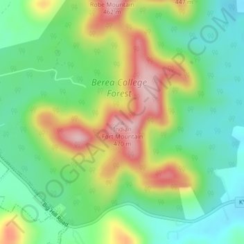
Name: Indian Fort Mountain topographic map, elevation, terrain.
Average elevation: 333 m
Minimum elevation: 250 m
Maximum elevation: 464 m
Make a donation
Gear up for your next adventure:
As an Amazon Associate, this site earns from qualifying purchases at no extra cost to you.
Other topographic maps
Click on a map to view its topography, its elevation and its terrain.
Berea
United States > Kentucky > Madison County
Berea is located on the border of the Cumberland Plateau. The area has a mountainous appearance, but most outcroppings in the area have a maximum elevation of 2,500 feet or 760 metres.
Average elevation: 300 m
Fort Boonesborough State Park
United States > Kentucky > Madison County > Boonesborough
Average elevation: 236 m
Berea
United States > Kentucky > Madison County
Berea is located on the border of the Cumberland Plateau. The area has a mountainous appearance, but most outcroppings in the area have a maximum elevation of 2,500 feet or 760 metres.
Average elevation: 300 m
Make a donation
Gear up for your next adventure:
As an Amazon Associate, this site earns from qualifying purchases at no extra cost to you.