Geolocate

Sellack topographic map

Click on the map to display elevation.

About this map

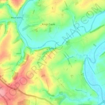
Name: Sellack topographic map, elevation, terrain.

Location: Sellack, Herefordshire, West Midlands, England, United Kingdom (51.92317 -2.67010 51.96338 -2.58699)

Average elevation: 67 m

Minimum elevation: 29 m

Maximum elevation: 130 m

Gear up for your next adventure:

🧰Survival Kit - Essential gear for emergencies in the wilderness
🛶Waterproof Dry Bags - Keep electronics and clothes dry during river crossings
🧭Orienteering Kit - Tools for map reading and navigation in the wild
🧢Beanie Hat - Keep your head warm in cold weather
🚲Handlebar Phone Mount - View topographic-map.com live while cycling

As an Amazon Associate, this site earns from qualifying purchases at no extra cost to you.