
Make a donation
Gear up for your next adventure:
As an Amazon Associate, this site earns from qualifying purchases at no extra cost to you.
Beau Bassin-Rose Hill topographic map
Click on the map to display elevation.
Make a donation
Gear up for your next adventure:
As an Amazon Associate, this site earns from qualifying purchases at no extra cost to you.
About this map
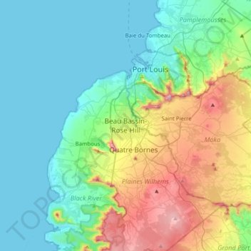
Name: Beau Bassin-Rose Hill topographic map, elevation, terrain.
Average elevation: 189 m
Minimum elevation: 0 m
Maximum elevation: 748 m
Make a donation
Gear up for your next adventure:
As an Amazon Associate, this site earns from qualifying purchases at no extra cost to you.
Other topographic maps
Click on a map to view its topography, its elevation and its terrain.
Curepipe
Curepipe (Mauritian Creole pronunciation: [kiːəpip]), also known as La Ville-Lumière (The City of Light), is a town in Mauritius, located mainly in the Plaines Wilhems District. Its eastern part lies in the Moka District. Known for its colonial architecture, the town is administered by the Municipal Council…
Average elevation: 538 m
Make a donation
Gear up for your next adventure:
As an Amazon Associate, this site earns from qualifying purchases at no extra cost to you.