
Make a donation
Gear up for your next adventure:
As an Amazon Associate, this site earns from qualifying purchases at no extra cost to you.
Tongliao City topographic map
Click on the map to display elevation.
Make a donation
Gear up for your next adventure:
As an Amazon Associate, this site earns from qualifying purchases at no extra cost to you.
Tongliao City
Tongliao's topography primarily consists of plains, though the northern stretch of the prefecture extends into the eastern foothills of the southern Greater Khingan. The central and eastern parts of the prefecture are marked by the plains of the Xiliao, Xinkai River (新开河), and Jiaolai rivers (教来河), collectively forming the Sanhe Plain (三河平原; 'three rivers' plain'). The highest point in the prefecture is Tunte'er Peak (吞特尔峰), at 1,444.2 m (4,738 ft).
Make a donation
Gear up for your next adventure:
As an Amazon Associate, this site earns from qualifying purchases at no extra cost to you.
About this map
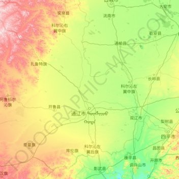
Name: Tongliao City topographic map, elevation, terrain.
Location: Tongliao City, Inner Mongolia, China (42.24027 119.23521 45.68146 123.71518)
Average elevation: 262 m
Minimum elevation: 44 m
Maximum elevation: 1,241 m
Make a donation
Gear up for your next adventure:
As an Amazon Associate, this site earns from qualifying purchases at no extra cost to you.
Other topographic maps
Click on a map to view its topography, its elevation and its terrain.
The Best View of North
China > Inner Mongolia > Hexigten Banner > Zhirui > Toudaogoumen
Average elevation: 1,600 m
Make a donation
Gear up for your next adventure:
As an Amazon Associate, this site earns from qualifying purchases at no extra cost to you.
Make a donation
Gear up for your next adventure:
As an Amazon Associate, this site earns from qualifying purchases at no extra cost to you.
Make a donation
Gear up for your next adventure:
As an Amazon Associate, this site earns from qualifying purchases at no extra cost to you.
Make a donation
Gear up for your next adventure:
As an Amazon Associate, this site earns from qualifying purchases at no extra cost to you.
Make a donation
Gear up for your next adventure:
As an Amazon Associate, this site earns from qualifying purchases at no extra cost to you.
Make a donation
Gear up for your next adventure:
As an Amazon Associate, this site earns from qualifying purchases at no extra cost to you.
Make a donation
Gear up for your next adventure:
As an Amazon Associate, this site earns from qualifying purchases at no extra cost to you.
Horqin Right Front Banner
China > Inner Mongolia > Horqin Right Front Banner > Ke'erqin
Average elevation: 348 m