
Helsingborg topographic map
Click on the map to display elevation.
About this map
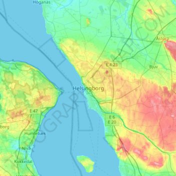
Name: Helsingborg topographic map, elevation, terrain.
Location: Helsingborg, Helsingborgs kommun, Skåne County, 252 68, Sweden (55.88421 12.54371 56.20421 12.86371)
Average elevation: 22 m
Minimum elevation: -1 m
Maximum elevation: 101 m
Other topographic maps
Click on a map to view its topography, its elevation and its terrain.
Ven
Along the entire coast, the island drops steeply towards the sea where the Öresund meets a rocky beach. This steep coast is called Backafall. Ven's backafall is a nature reserve established in 1990. There are no large forests, but smaller stands of trees occur closest to the coast the slightly higher…
Average elevation: 13 m
Kullaberg
Sweden > Skåne County > Mölle
Kullaberg (Swedish pronunciation: [kɵlaˈbærj]) is a peninsula and nature reserve of land protruding into the Kattegat in Höganäs Municipality near the town of Mölle in southwest Sweden. The site in the province of Skåne is an area of considerable biodiversity supporting a number of rare species and has…
Average elevation: 22 m
Ven
Sweden > Skåne County > Tuna
Along the entire coast, the island drops steeply towards the sea where the Öresund meets a rocky beach. This steep coast is called Backafall. Ven's backafall is a nature reserve established in 1990. There are no large forests, but smaller stands of trees occur closest to the coast the slightly higher…
Average elevation: 13 m