
Make a donation
Gear up for your next adventure:
As an Amazon Associate, this site earns from qualifying purchases at no extra cost to you.
Otay Mesa topographic map
Click on the map to display elevation.
Make a donation
Gear up for your next adventure:
As an Amazon Associate, this site earns from qualifying purchases at no extra cost to you.
About this map
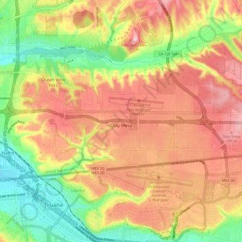
Name: Otay Mesa topographic map, elevation, terrain.
Average elevation: 112 m
Minimum elevation: 12 m
Maximum elevation: 199 m
Make a donation
Gear up for your next adventure:
As an Amazon Associate, this site earns from qualifying purchases at no extra cost to you.
Other topographic maps
Click on a map to view its topography, its elevation and its terrain.
Lake Murray Reservoir
United States > California > San Diego County > San Diego > San Carlos
Average elevation: 178 m
Make a donation
Gear up for your next adventure:
As an Amazon Associate, this site earns from qualifying purchases at no extra cost to you.
Rancho Peñasquitos
United States > California > San Diego County > San Diego
The highest point in the community is Black Mountain, which rises to an elevation of 1,500 feet (460 m).
Average elevation: 157 m
San Diego
United States > California > San Diego County > San Diego
The climate in San Diego, like most of Southern California, often varies significantly over short geographical distances, resulting in microclimates. In San Diego, this is mostly because of the city's topography (the Bay, and the numerous hills, mountains, and canyons). Frequently, particularly during the "May…
Average elevation: 57 m
Make a donation
Gear up for your next adventure:
As an Amazon Associate, this site earns from qualifying purchases at no extra cost to you.
Torrey Pines State Natural Reserve
United States > California > San Diego County > San Diego
Average elevation: 37 m
La Jolla Shores Beach
United States > California > San Diego County > San Diego
Average elevation: 39 m
Make a donation
Gear up for your next adventure:
As an Amazon Associate, this site earns from qualifying purchases at no extra cost to you.
Make a donation
Gear up for your next adventure:
As an Amazon Associate, this site earns from qualifying purchases at no extra cost to you.