Geolocate

San Augustin topographic map

Click on the map to display elevation.

About this map

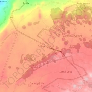
Name: San Augustin topographic map, elevation, terrain.

Location: San Augustin, Bohol, Central Visayas, 6331, Philippines (9.91042 124.04923 9.95042 124.08923)

Average elevation: 224 m

Minimum elevation: 40 m

Maximum elevation: 294 m

Other topographic maps

Click on a map to view its topography, its elevation and its terrain.

Bingag

Philippines > Bohol > Dauis

Average elevation: 19 m

Boyo-an

Philippines > Bohol > Candijay

Average elevation: 43 m

Panglao

Philippines > Bohol > Panglao

Average elevation: 4 m

Gear up for your next adventure:

🧥Softshell Hiking Jacket - The perfect balance of wind protection and breathability
💧Collapsible Water Bottle - Space-saving water bottle for outdoor activities
🔦LED Flashlight - Powerful and long-lasting flashlight for camping and emergencies
🧰Emergency Multi-Tool - Compact multi-tool for outdoor survival
👟Sport Hiking Sandals - Breathable footwear for water crossings and camp rest

As an Amazon Associate, this site earns from qualifying purchases at no extra cost to you.