Geolocate

Ratujaya topographic map

Click on the map to display elevation.

About this map

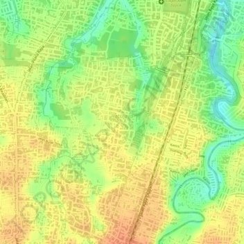
Name: Ratujaya topographic map, elevation, terrain.

Location: Ratujaya, Cipayung, Depok, Bogor, West Java, Java, Indonesia (-6.42911 106.79919 -6.41209 106.82191)

Average elevation: 97 m

Minimum elevation: 71 m

Maximum elevation: 112 m

Other topographic maps

Click on a map to view its topography, its elevation and its terrain.

Alun-alun Sukamaju

Indonesia > West Java > Bogor > Depok > Sukamaju

Average elevation: 100 m

Kalibaru

Indonesia > West Java > Bogor > Depok

Average elevation: 102 m

Cimpaeun

Indonesia > West Java > Bogor > Depok

Average elevation: 109 m

Bakti Jaya

Indonesia > West Java > Bogor > Depok

Average elevation: 82 m

Situ Sidomukti

Indonesia > West Java > Bogor > Depok > Sukamaju

Average elevation: 97 m

Krukut

Indonesia > West Java > Bogor > Depok > Krukut

Average elevation: 64 m

Jatijajar

Indonesia > West Java > Bogor > Depok

Average elevation: 95 m

Harjamukti

Indonesia > West Java > Bogor > Depok

Average elevation: 77 m

Mekar Jaya

Indonesia > West Java > Bogor > Depok

Average elevation: 82 m

Gear up for your next adventure:

💧Filtered Water Bottle - Safe drinking water on the go
🔋Solar Power Bank - Keep your GPS and devices charged during long outdoor trips
🥾Waterproof Hiking Boots - Essential footwear for rugged terrain and wet Canadian trails
🧰Multitool Knife - Compact and versatile tool for outdoor use
🥫Freeze-Dried Meals - Lightweight, high-calorie nutrition for multi-day treks

As an Amazon Associate, this site earns from qualifying purchases at no extra cost to you.