Geolocate

Kalibaru topographic map

Click on the map to display elevation.

About this map

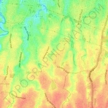
Name: Kalibaru topographic map, elevation, terrain.

Location: Kalibaru, Depok, Bogor, West Java, Java, 16414, Indonesia (-6.44983 106.81900 -6.40983 106.85900)

Average elevation: 102 m

Minimum elevation: 74 m

Maximum elevation: 119 m

Other topographic maps

Click on a map to view its topography, its elevation and its terrain.

Cipayung

Indonesia > West Java > Bogor > Depok

Average elevation: 98 m

Mampang

Indonesia > West Java > Bogor > Depok

Average elevation: 83 m

Ratujaya

Indonesia > West Java > Bogor > Depok

Average elevation: 97 m

Alun-alun Sukamaju

Indonesia > West Java > Bogor > Depok > Sukamaju

Average elevation: 100 m

Situ Sidomukti

Indonesia > West Java > Bogor > Depok > Sukamaju

Average elevation: 97 m

Krukut

Indonesia > West Java > Bogor > Depok > Krukut

Average elevation: 64 m

Curug

Indonesia > West Java > Bogor > Depok

Average elevation: 85 m

Cinere

Indonesia > West Java > Bogor > Depok

Average elevation: 57 m

Gear up for your next adventure:

💡LED Headlamp - Hands-free illumination for night hiking and camping
🥾Lightweight Hiking Shoes - Comfortable shoes for day hikes
Camping Tent - Weather-resistant tents suitable for 2 to 6 people
🥾Mountaineering Boots - Supportive boots for climbing and high-altitude hiking
🧢Outdoor Cap - Protective cap for sun and rain during hikes

As an Amazon Associate, this site earns from qualifying purchases at no extra cost to you.