Geolocate

Breviken topographic map

Click on the map to display elevation.

About this map

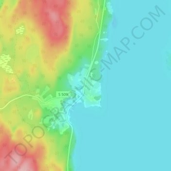
Name: Breviken topographic map, elevation, terrain.

Location: Breviken, Årjängs kommun, Värmland County, 672 91, Sweden (59.27490 12.08687 59.31490 12.12687)

Average elevation: 135 m

Minimum elevation: 93 m

Maximum elevation: 242 m

Other topographic maps

Click on a map to view its topography, its elevation and its terrain.

Kils kommun

Sweden > Värmland County

Average elevation: 104 m

Hammarö kommun

Sweden > Värmland County

Average elevation: 45 m

Sunne kommun

Sweden > Värmland County

Average elevation: 194 m

Hammarö kommun

Sweden > Värmland County

Average elevation: 45 m

Hagfors kommun

Sweden > Värmland County

Average elevation: 257 m

Torsby kommun

Sweden > Värmland County

Average elevation: 356 m

Säffle kommun

Sweden > Värmland County

Average elevation: 89 m

Pottern

Sweden > Värmland County

Average elevation: 145 m

Karlstads kommun

Sweden > Värmland County

Average elevation: 109 m

Filipstads kommun

Sweden > Värmland County

Average elevation: 241 m

Storfors kommun

Sweden > Värmland County

Average elevation: 158 m

Gear up for your next adventure:

Bushcraft Tarp - Versatile emergency shelter or gear protection
🧴Insect Repellent - Protect yourself from bugs during outdoor adventures
🥾Waterproof Hiking Boots - Boots keeping your feet dry in wet conditions
🔋Solar Power Bank - Keep your GPS and devices charged during long outdoor trips
🧳Compression Sacks - Maximize space in your backpack by shrinking gear

As an Amazon Associate, this site earns from qualifying purchases at no extra cost to you.