Geolocate

Babbitt topographic map

Click on the map to display elevation.

About this map

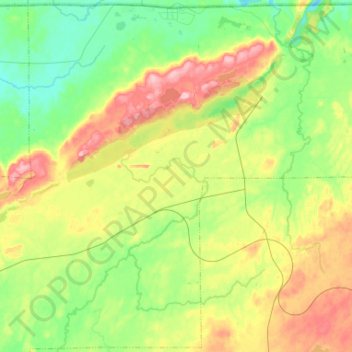
Name: Babbitt topographic map, elevation, terrain.

Location: Babbitt, Saint Louis County, Minnesota, United States (47.54339 -92.05501 47.71631 -91.79289)

Average elevation: 484 m

Minimum elevation: 430 m

Maximum elevation: 576 m

Other topographic maps

Click on a map to view its topography, its elevation and its terrain.

Melrude

United States > Minnesota > Saint Louis County

Average elevation: 413 m

Ash Lake

United States > Minnesota > Saint Louis County

Average elevation: 413 m

Gear up for your next adventure:

🛏️Sleeping Bag - Warm and compact sleeping bags for outdoor camping
🦟Insect Repellent - Keep mosquitoes and black flies away in wooded areas
💧Hydration Bladder - Hands-free hydration solution for long treks
🧣Evaporative Cooling Towel - Beat the heat during intense summer climbs
👟Trail Running Shoes - Agile footwear for fast-paced topographic exploration

As an Amazon Associate, this site earns from qualifying purchases at no extra cost to you.