Geolocate

Calverton topographic map

Click on the map to display elevation.

About this map

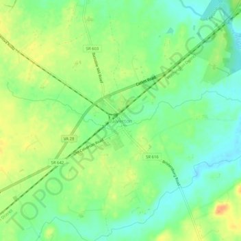
Name: Calverton topographic map, elevation, terrain.

Location: Calverton, Fauquier County, Virginia, 20138, United States (38.61207 -77.69055 38.65207 -77.65055)

Average elevation: 81 m

Minimum elevation: 64 m

Maximum elevation: 101 m

Other topographic maps

Click on a map to view its topography, its elevation and its terrain.

Bealeton

United States > Virginia > Fauquier County > Bealeton

Average elevation: 100 m

Marshall

United States > Virginia > Fauquier County

Average elevation: 189 m

New Baltimore

United States > Virginia > Fauquier County

Average elevation: 148 m

Rectortown

United States > Virginia > Fauquier County

Average elevation: 161 m

Upperville

United States > Virginia > Fauquier County

Average elevation: 172 m

Broad Run

United States > Virginia > Fauquier County > Broad Run

Average elevation: 164 m

Gear up for your next adventure:

🧰Emergency Multi-Tool - Compact multi-tool for outdoor survival
❄️Traction Ice Cleats - Slip-on spikes for icy trails and winter hiking
🧤Insulated Winter Gloves - Heavy-duty protection for sub-zero Canadian adventures
🎒Hiking Backpack - Lightweight and ergonomic backpacks for day hikes or multi-day treks
🕶️Polarized Sunglasses - Reduces glare from snow and water at high elevations

As an Amazon Associate, this site earns from qualifying purchases at no extra cost to you.