Geolocate

Lake Wappapello topographic map

Click on the map to display elevation.

About this map

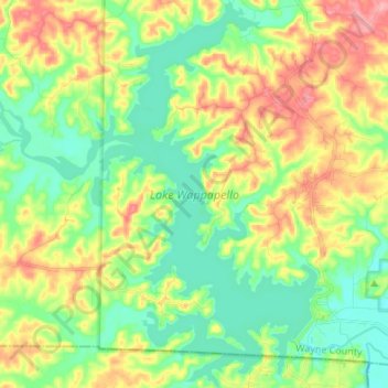
Name: Lake Wappapello topographic map, elevation, terrain.

Location: Lake Wappapello, Wayne County, Missouri, United States (36.91505 -90.37604 37.02292 -90.27485)

Average elevation: 138 m

Minimum elevation: 99 m

Maximum elevation: 200 m

Other topographic maps

Click on a map to view its topography, its elevation and its terrain.

Keener Cave

United States > Missouri > Wayne County

Average elevation: 135 m

Shook

United States > Missouri > Wayne County

Average elevation: 151 m

Gear up for your next adventure:

Camping Tent - Weather-resistant tents suitable for 2 to 6 people
🧢Sun Hat - Wide-brim hat for sun protection
🛏️Sleeping Bag - Warm and compact sleeping bags for outdoor camping
🥾Waterproof Hiking Shoes - Durable shoes for wet and rugged trails
Camping Essentials - All-in-one gear for a comfortable camping trip

As an Amazon Associate, this site earns from qualifying purchases at no extra cost to you.