Geolocate

Shirebrook topographic map

Click on the map to display elevation.

About this map
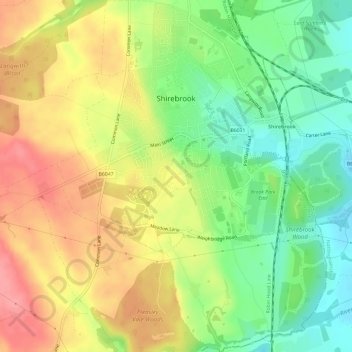
Name: Shirebrook topographic map, elevation, terrain.

Location: Shirebrook, Bolsover, Derbyshire, East Midlands, England, United Kingdom (53.18061 -1.24080 53.21626 -1.19506)

Average elevation: 114 m

Minimum elevation: 71 m

Maximum elevation: 159 m

Other topographic maps

Click on a map to view its topography, its elevation and its terrain.

Stainsby

United Kingdom > England > Derbyshire > Bolsover

Average elevation: 138 m

Astwith

United Kingdom > England > Derbyshire > Bolsover

Average elevation: 146 m

Gear up for your next adventure:

🧢Outdoor Cap - Protective cap for sun and rain during hikes
🧥Fleece Jacket - Warm and lightweight jacket for layering
🏕️Camping Hammock - Integrated protection for sleeping between trees
🧊Insulated Water Bottle - Keeps drinks cold in summer and prevents freezing in winter
🧴Insect Repellent - Protect yourself from bugs during outdoor adventures

As an Amazon Associate, this site earns from qualifying purchases at no extra cost to you.