Geolocate

Dorfen topographic map

Click on the map to display elevation.

About this map

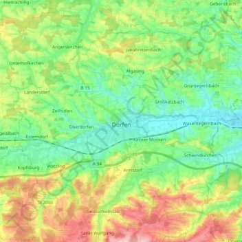
Name: Dorfen topographic map, elevation, terrain.

Location: Dorfen, Landkreis Erding, Bavaria, 84405, Germany (48.22512 12.06959 48.32756 12.25526)

Average elevation: 492 m

Minimum elevation: 427 m

Maximum elevation: 613 m

Other topographic maps

Click on a map to view its topography, its elevation and its terrain.

Feichten

Germany > Bavaria > Landkreis Erding > Burgrain

Average elevation: 550 m

Fendsbach

Germany > Bavaria > Landkreis Erding > Wartenberg

Average elevation: 451 m

Pretzen

Germany > Bavaria > Landkreis Erding > Erding

Average elevation: 481 m

Grashausen

Germany > Bavaria > Landkreis Erding > Ottenhofen

Average elevation: 511 m

Gear up for your next adventure:

🪑Ultralight Camping Stool - Compact seating for rest stops during long hikes
🥾Light Trekking Boots - Supportive boots for multi-day treks
🧦Merino Wool Socks - Moisture-wicking comfort for long-distance hiking
🥾Trail Hiking Socks - Comfortable socks to prevent blisters and fatigue
🥾Waterproof Hiking Boots - Boots keeping your feet dry in wet conditions

As an Amazon Associate, this site earns from qualifying purchases at no extra cost to you.