Geolocate

Pretzen topographic map

Click on the map to display elevation.

About this map

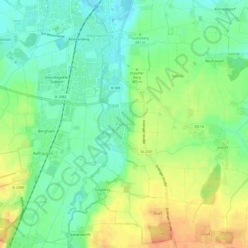
Name: Pretzen topographic map, elevation, terrain.

Location: Pretzen, Erding, Landkreis Erding, Bavaria, 85435, Germany (48.25920 11.89273 48.29920 11.93273)

Average elevation: 481 m

Minimum elevation: 462 m

Maximum elevation: 506 m

Other topographic maps

Click on a map to view its topography, its elevation and its terrain.

Langengeisling

Germany > Bavaria > Landkreis Erding > Erding

Average elevation: 451 m

Erding

Germany > Bavaria > Landkreis Erding > Erding

Average elevation: 460 m

Gear up for your next adventure:

🧭Orienteering Kit - Tools for map reading and navigation in the wild
🥾Trekking Boots - Durable boots for long-distance trekking
🔋Emergency Crank Radio - Weather alerts and power without needing batteries
🔭Outdoor Binoculars - Lightweight binoculars for birdwatching and hiking
🥾Lightweight Hiking Boots - Boots for comfort and mobility on long hikes

As an Amazon Associate, this site earns from qualifying purchases at no extra cost to you.