
Make a donation
Gear up for your next adventure:
As an Amazon Associate, this site earns from qualifying purchases at no extra cost to you.
Trnava topographic map
Click on the map to display elevation.
Make a donation
Gear up for your next adventure:
As an Amazon Associate, this site earns from qualifying purchases at no extra cost to you.
Trnava
The municipality lies at an altitude of 144 metres (472 ft) and covers an area of 71.53 km2 (27.62 sq mi) (2025). It is located in the Danubian Lowland on the Trnávka river, around 45 kilometres (28 mi) north-east of Bratislava, 50 kilometres (31 mi) west of Nitra and around 70 kilometres (43 mi) from the Czech border. The closest mountain ranges are the Little Carpathians to the west and the Považský Inovec to the north-east of the city.
Make a donation
Gear up for your next adventure:
As an Amazon Associate, this site earns from qualifying purchases at no extra cost to you.
About this map
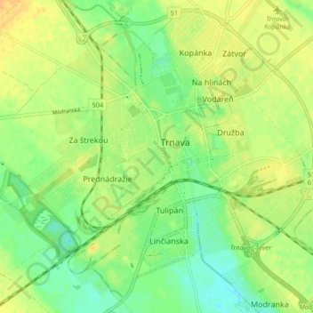
Name: Trnava topographic map, elevation, terrain.
Location: Trnava, District of Trnava, Region of Trnava, Slovakia (48.34915 17.54039 48.39942 17.62150)
Average elevation: 151 m
Minimum elevation: 136 m
Maximum elevation: 165 m
Make a donation
Gear up for your next adventure:
As an Amazon Associate, this site earns from qualifying purchases at no extra cost to you.
Other topographic maps
Click on a map to view its topography, its elevation and its terrain.
Bratislava
Slovakia > Region of Bratislava > District of Bratislava I > Old Town
The Carpathian mountain range begins in city territory with the Little Carpathians (Malé Karpaty). The Záhorie and Danubian lowlands stretch into Bratislava. The city's lowest point is at the Danube's surface at 126 metres (413 ft) above mean sea level, and the highest point is Devínska Kobyla at 514 metres…
Average elevation: 175 m
Tatra Mountains
The Tatras lie in the temperate zone of Central Europe. They are an important barrier to the movements of air masses. Their mountainous topography causes one of the most diverse climates in that region.
Average elevation: 1,001 m
Make a donation
Gear up for your next adventure:
As an Amazon Associate, this site earns from qualifying purchases at no extra cost to you.
Bratislava
Slovakia > Region of Bratislava
The Carpathian mountain range begins in city territory with the Little Carpathians (Malé Karpaty). The Záhorie and Danubian lowlands stretch into Bratislava. The city's lowest point is at the Danube's surface at 126 metres (413 ft) above mean sea level, and the highest point is Devínska Kobyla at 514 metres…
Average elevation: 172 m
Make a donation
Gear up for your next adventure:
As an Amazon Associate, this site earns from qualifying purchases at no extra cost to you.
Tatra Mountains
The Tatras lie in the temperate zone of Central Europe. They are an important barrier to the movements of air masses. Their mountainous topography causes one of the most diverse climates in that region.
Average elevation: 1,001 m
Nitra
Slovakia > Region of Nitra > District of Nitra
Nitra lies at an altitude of 190 metres (623 ft) above sea level and covers an area of 100.48 square kilometres (38.8 sq mi). It is located in the Nitra River valley in the Danubian Lowland, where the bigger part of the city is located. A smaller part is located at the southernmost reaches of the Tribeč…
Average elevation: 197 m
Make a donation
Gear up for your next adventure:
As an Amazon Associate, this site earns from qualifying purchases at no extra cost to you.
Sereď
The municipality lies at an altitude of 128 metres (420 ft) and covers an area of 30.72 km2 (11.86 sq mi) (2025). It is located in the Danubian Lowland on the Váh river, around 20 kilometres (12 mi) south-east of Trnava, 33 kilometres (21 mi) west of Nitra and around 55 kilometres (34 mi) east from…
Average elevation: 132 m
Mníšek nad Popradom
The municipality lies at an altitude of 439 metres (1,440 ft) and covers an area of 17.93 km2 (6.92 sq mi) (2025). The village lies near the Poprad river and is directly at the border with Poland, with a 24-hour border crossing.
Average elevation: 584 m
Make a donation
Gear up for your next adventure:
As an Amazon Associate, this site earns from qualifying purchases at no extra cost to you.
Mokrance
Slovakia > Region of Košice > District of Košice - okolie
The municipality lies at an altitude of 200 metres (660 ft) and covers an area of 23.41 km2 (9.04 sq mi) (2025).
Average elevation: 230 m
Košice
Košice lies at an altitude of 206 metres (676 ft) above sea level and covers an area of 242.77 square kilometres (93.7 sq mi). It is located in eastern Slovakia, about 20 kilometres (12 mi) from the Hungarian, 80 kilometres (50 mi) from the Ukrainian, and 90 kilometres (56 mi) from the Polish borders. It is…
Average elevation: 314 m
Martin
Slovakia > Region of Žilina > District of Martin
Martin lies at an altitude of 395 metres (1,296 ft) above sea level and covers an area of 67.74 square kilometres (26.2 sq mi). It is located in northern Slovakia, in the Turiec Basin, just south of the confluence of the Turiec river with Váh. Mountain ranges in the proximity of the city are Malá Fatra…
Average elevation: 484 m
Make a donation
Gear up for your next adventure:
As an Amazon Associate, this site earns from qualifying purchases at no extra cost to you.
Tomášovo
Slovakia > Region of Banská Bystrica > District of Rimavská Sobota > Hnúšťa > Polom
Average elevation: 649 m
Banská Bystrica
Slovakia > Region of Banská Bystrica > District of Banská Bystrica
Banská Bystrica lies at an altitude of 368 metres (1,207 ft) above sea level and covers an area of 103.36 square kilometres (39.9 sq mi). It is about halfway between Slovakia's two largest cities, 208 kilometres (129 mi) north-east from Slovakia's capital Bratislava and 217 kilometres (135 mi) west of…
Average elevation: 434 m
Bratislava
Slovakia > Region of Bratislava
The Carpathian mountain range begins in city territory with the Little Carpathians (Malé Karpaty). The Záhorie and Danubian lowlands stretch into Bratislava. The city's lowest point is at the Danube's surface at 126 metres (413 ft) above mean sea level, and the highest point is Devínska Kobyla at 514 metres…
Average elevation: 168 m
Michalovce
Slovakia > Region of Košice > District of Michalovce
The municipality lies at an altitude of 113 metres (371 ft) and covers an area of 52.80 km2 (20.39 sq mi) (2025).
Average elevation: 114 m
Make a donation
Gear up for your next adventure:
As an Amazon Associate, this site earns from qualifying purchases at no extra cost to you.
Tatra Mountains
The Tatras lie in the temperate zone of Central Europe. They are an important barrier to the movements of air masses. Their mountainous topography causes one of the most diverse climates in that region.
Average elevation: 1,001 m
Senica
Slovakia > Region of Trnava > District of Senica
The municipality lies at an altitude of 206 metres (676 ft) and covers an area of 50.33 km2 (19.43 sq mi) (2025).
Average elevation: 225 m
Bratislava
Slovakia > Region of Bratislava
The Carpathian mountain range begins in city territory with the Little Carpathians (Malé Karpaty). The Záhorie and Danubian lowlands stretch into Bratislava. The city's lowest point is at the Danube's surface at 126 metres (413 ft) above mean sea level, and the highest point is Devínska Kobyla at 514 metres…
Average elevation: 168 m
Make a donation
Gear up for your next adventure:
As an Amazon Associate, this site earns from qualifying purchases at no extra cost to you.
Tatra Mountains
The Tatras lie in the temperate zone of Central Europe. They are an important barrier to the movements of air masses. Their mountainous topography causes one of the most diverse climates in that region.
Average elevation: 1,001 m
Gerlachovský štít
Slovakia > Region of Prešov > District of Poprad
Gerlachovský štít (Slovak pronunciation, translated into English as Gerlachov Peak, German: Gerlsdorfer Spitze, Hungarian: Gerlachfalvi-csúcs), informally referred to as Gerlach, is the highest peak in the High Tatras, in Slovakia, and in the Carpathian Mountains. Its elevation is usually listed at 2654.4…
Average elevation: 2,103 m
Make a donation
Gear up for your next adventure:
As an Amazon Associate, this site earns from qualifying purchases at no extra cost to you.
Banská Bystrica
Slovakia > Region of Banská Bystrica > District of Banská Bystrica
Banská Bystrica lies at an altitude of 362 metres (1,188 ft) above sea level and covers an area of 103.37 square kilometres (39.9 sq mi). It is about halfway between Slovakia's two largest cities, 208 kilometres (129 mi) north-east from Slovakia's capital Bratislava and 217 kilometres (135 mi) west of…
Average elevation: 564 m
Bratislava
Slovakia > Region of Bratislava
The Carpathian mountain range begins in city territory with the Little Carpathians (Malé Karpaty). The Záhorie and Danubian lowlands stretch into Bratislava. The city's lowest point is at the Danube's surface at 126 metres (413 ft) above mean sea level, and the highest point is Devínska Kobyla at 514 metres…
Average elevation: 172 m
Make a donation
Gear up for your next adventure:
As an Amazon Associate, this site earns from qualifying purchases at no extra cost to you.
Bratislava
Slovakia > Region of Bratislava
The Carpathian mountain range begins in city territory with the Little Carpathians (Malé Karpaty). The Záhorie and Danubian lowlands stretch into Bratislava. The city's lowest point is at the Danube's surface at 126 metres (413 ft) above mean sea level, and the highest point is Devínska Kobyla at 514 metres…
Average elevation: 169 m
Rysy
Slovakia > Region of Prešov > District of Poprad
It is possible to reach the peak from the Slovak side, starting at Štrbské pleso and passing Chata pod Rysmi, a mountain chalet at an altitude of 2,250 m (7,380 ft). Between November 1 and June 15, the trail and chalet on the Slovak side are closed.
Average elevation: 2,005 m
Kremnica
Slovakia > Region of Banská Bystrica
Kremnica lies at an altitude of 564 metres (1,850 ft) above sea level and covers an area of 43.136 square kilometres (16.7 sq mi). It is located in the Kremnica Mountains on the brook Kremnický potok, which is a tributary of the Hron River. It is located around 20 kilometres (12 mi) west of Banská Bystrica…
Average elevation: 786 m
Make a donation
Gear up for your next adventure:
As an Amazon Associate, this site earns from qualifying purchases at no extra cost to you.
Marianka
Slovakia > Region of Bratislava > District of Malacky > Bratislava
The municipality lies at an altitude of 230 metres (750 ft) and covers an area of 3.22 km2 (1.24 sq mi) (2025).
Average elevation: 249 m
Make a donation
Gear up for your next adventure:
As an Amazon Associate, this site earns from qualifying purchases at no extra cost to you.
Olováry
Slovakia > Region of Banská Bystrica > District of Veľký Krtíš
The municipality lies at an altitude of 190 metres (620 ft) and covers an area of 18.61 km2 (7.19 sq mi) (2025).
Average elevation: 211 m
Veľká Javorina
Slovakia > Region of Trenčín > District of Nové Mesto nad Váhom
The massif of Velká Javořina is located in the southwest part of the White Carpathians and is built of flysch rocks with significant thickness, in which layers of sandstone (dating from the Upper Cretaceous to the Lower Paleocene) and fine-grained marine sediments (shales and marls) rhythmically repeat. The…
Average elevation: 774 m
Piešťany
Piešťany is situated in the western part of Slovakia, in the valley of the Váh river, at an elevation of 162 metres (531.50 feet). The Považský Inovec mountains form the eastern boundary of this part of the Váh valley. The highest hill of these mountains, Inovec 1,042 m (3,418.64 ft), is about 25 km (16…
Average elevation: 196 m
Stupava
Slovakia > Region of Bratislava
The town is located in the Záhorie lowland, under the Little Carpathians, around 15 km (9 mi) north of Bratislava at an altitude of 182 metres. It has 15, 095 inhabitants as of 2021 and has a land area of 67.17 km2 (26 sq mi). Apart from the core part of the city, Mást (German: Maaßt, Hungarian: Mászt),…
Average elevation: 237 m
Make a donation
Gear up for your next adventure:
As an Amazon Associate, this site earns from qualifying purchases at no extra cost to you.
Tatra Mountains
The Tatras lie in the temperate zone of Central Europe. They are an important barrier to the movements of air masses. Their mountainous topography causes one of the most diverse climates in that region.
Average elevation: 1,001 m
Make a donation
Gear up for your next adventure:
As an Amazon Associate, this site earns from qualifying purchases at no extra cost to you.
Lendak
Slovakia > Region of Prešov > District of Kežmarok
The municipality lies at an altitude of 749 metres and covers an area of 19.658 km². It has a population of about 5400 people.
Average elevation: 896 m
Žilina
Slovakia > Region of Žilina > District of Žilina
Žilina lies at an altitude of 342 metres (1,122 ft) above sea level and covers an area of 80.03 square kilometres (30.9 sq mi). It is located in the Upper Váh region (Slovak: Horné Považie) at the confluence of three rivers: Váh, flowing from the east into the south-west, Kysuca, flowing from the north…
Average elevation: 424 m
Make a donation
Gear up for your next adventure:
As an Amazon Associate, this site earns from qualifying purchases at no extra cost to you.
Plechotice
Slovakia > Region of Košice > District of Trebišov
The village lies at an altitude of 142 metres (466 ft) and covers an area of 12.936 km².
Average elevation: 150 m
Galanta
Slovakia > Region of Trnava > District of Galanta
The municipality lies at an altitude of 119 metres (390 ft) and covers an area of 33.91 km2 (13.09 sq mi) (2024).
Average elevation: 119 m
Make a donation
Gear up for your next adventure:
As an Amazon Associate, this site earns from qualifying purchases at no extra cost to you.
Michalovce
Slovakia > Region of Košice > District of Michalovce
The municipality lies at an altitude of 113 metres (371 ft) and covers an area of 52.80 km2 (20.39 sq mi) (2024).
Average elevation: 114 m
Make a donation
Gear up for your next adventure:
As an Amazon Associate, this site earns from qualifying purchases at no extra cost to you.
Pastovce
Slovakia > Region of Nitra > District of Levice
The village lies at an altitude of 124 metres and covers an area of 12.859 km2. It has a population of about 540 people.
Average elevation: 135 m
Košice
Košice lies at an altitude of 206 metres (676 ft) above sea level and covers an area of 242.77 square kilometres (93.7 sq mi). It is located in eastern Slovakia, about 20 kilometres (12 mi) from the Hungarian, 80 kilometres (50 mi) from the Ukrainian, and 90 kilometres (56 mi) from the Polish borders. It is…
Average elevation: 314 m
Trenčín
Trenčín lies at an altitude of 262 metres (860 ft) above sea level and covers an area of 82 square kilometres (31.7 sq mi). It lies in the Trenčín Basin of north-western Slovakia, which is surrounded by the Strážov Mountains, Považský Inovec and White Carpathians, with the last mentioned being a…
Average elevation: 307 m
Make a donation
Gear up for your next adventure:
As an Amazon Associate, this site earns from qualifying purchases at no extra cost to you.
Šurany
Šurany lies at an altitude of 123 metres (404 ft) above sea level and covers an area of 59.812 square kilometres (23.1 sq mi). It is located in the Danubian Lowland near the Nitra River, 13 kilometres (8 mi) away from Nové Zámky and around 100 kilometres (62 mi) from Bratislava.
Average elevation: 123 m
Make a donation
Gear up for your next adventure:
As an Amazon Associate, this site earns from qualifying purchases at no extra cost to you.
Tatranská Javorina
Slovakia > Region of Prešov > District of Poprad
The municipality lies at an altitude of 1000 metres. It is located in the Javorová Valley in the Tatra Mountains at the Polish-Slovak border.
Average elevation: 1,381 m
Hul
Slovakia > Region of Nitra > District of Nové Zámky
The village lies at an altitude of 124 metres and covers an area of 12.624 km2. It has a population of about 1240 people.
Average elevation: 132 m
Brezina
Slovakia > Region of Košice > District of Trebišov
The municipality lies at an altitude of 186 metres (610 ft) and covers an area of 12.96 km2 (5.00 sq mi) (2024).
Average elevation: 237 m
Make a donation
Gear up for your next adventure:
As an Amazon Associate, this site earns from qualifying purchases at no extra cost to you.
Low Tatras National Park
Slovakia > Region of Banská Bystrica > District of Brezno
Average elevation: 890 m
Modra nad Cirochou
Slovakia > Region of Prešov > District of Humenné
The municipality lies at an altitude of 210 metres and covers an area of 7.345 km². It has a population of about 1030 people.
Average elevation: 264 m
Make a donation
Gear up for your next adventure:
As an Amazon Associate, this site earns from qualifying purchases at no extra cost to you.
Vrbovce
Slovakia > Region of Trenčín > District of Myjava
The municipality lies at an altitude of 317 metres and covers an area of 51.520 km2. From the northern side the village cadastre is bounded with the state border and the border crossing with the Czech Republic.
Average elevation: 428 m
Kriváň
Slovakia > Region of Prešov > District of Poprad > Vysoké Tatry
The relative elevations of the two mountains were determined by the English natural historian Robert Townson, who ascended both peaks in August 1793 and also made an early recorded comment on Kriváň's aesthetic appeal.
Average elevation: 1,913 m
Make a donation
Gear up for your next adventure:
As an Amazon Associate, this site earns from qualifying purchases at no extra cost to you.
Chopok
Slovakia > Region of Banská Bystrica > District of Brezno > Horná Lehota
Average elevation: 1,642 m
Castle
Slovakia > Region of Nitra > District of Zlaté Moravce > Vieska nad Žitavou
Average elevation: 187 m
Brusnica
Slovakia > Region of Prešov > District of Stropkov
The municipality lies at an altitude of 191 metres (627 ft) and covers an area of 14.28 km2 (5.51 sq mi) (2024). The village has a significant Rusyn minority (32%) and smaller Romani minority (2%), along with the majority of Slovaks (65%).
Average elevation: 286 m
Make a donation
Gear up for your next adventure:
As an Amazon Associate, this site earns from qualifying purchases at no extra cost to you.
Prešov
Slovakia > Region of Prešov > District of Prešov
The municipality lies at an altitude of 296 metres (971 ft) and covers an area of 71.09 km2 (27.45 sq mi) (2025). It is located in north-eastern Slovakia, at the northern reaches of the Košice Basin, at the confluence of the Torysa river with its tributary Sekčov. Mountain ranges nearby include Slanské…
Average elevation: 314 m
Oravská Polhora
Slovakia > Region of Žilina > District of Námestovo
The municipality lies at an altitude of 688 metres and covers an area of 84.519 km². It has a population of about 3,635 people.
Average elevation: 865 m
Make a donation
Gear up for your next adventure:
As an Amazon Associate, this site earns from qualifying purchases at no extra cost to you.
Hubice
Slovakia > Region of Trnava > District of Dunajská Streda
The municipality lies at an altitude of 126 metres and covers an area of 5.360 km². It has a population of about 510 people.
Average elevation: 124 m
Make a donation
Gear up for your next adventure:
As an Amazon Associate, this site earns from qualifying purchases at no extra cost to you.
Bratislava
Slovakia > Region of Bratislava
The Carpathian mountain range begins in city territory with the Little Carpathians (Malé Karpaty). The Záhorie and Danubian lowlands stretch into Bratislava. The city's lowest point is at the Danube's surface at 126 metres (413 ft) above mean sea level, and the highest point is Devínska Kobyla at 514 metres…
Average elevation: 172 m
Make a donation
Gear up for your next adventure:
As an Amazon Associate, this site earns from qualifying purchases at no extra cost to you.