
Make a donation
Gear up for your next adventure:
As an Amazon Associate, this site earns from qualifying purchases at no extra cost to you.
Košice topographic map
Click on the map to display elevation.
Make a donation
Gear up for your next adventure:
As an Amazon Associate, this site earns from qualifying purchases at no extra cost to you.
Košice
Košice lies at an altitude of 206 metres (676 ft) above sea level and covers an area of 242.77 square kilometres (93.7 sq mi). It is located in eastern Slovakia, about 20 kilometres (12 mi) from the Hungarian, 80 kilometres (50 mi) from the Ukrainian, and 90 kilometres (56 mi) from the Polish borders. It is about 400 kilometres (249 mi) east of Slovakia's capital Bratislava and a chain of villages connects it to Prešov which is about 36 kilometres (22 mi) to the north.
Make a donation
Gear up for your next adventure:
As an Amazon Associate, this site earns from qualifying purchases at no extra cost to you.
About this map
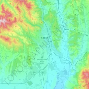
Name: Košice topographic map, elevation, terrain.
Location: Košice, Region of Košice, Eastern Slovakia, Slovakia (48.57004 21.11996 48.82451 21.35821)
Average elevation: 314 m
Minimum elevation: 166 m
Maximum elevation: 960 m
Make a donation
Gear up for your next adventure:
As an Amazon Associate, this site earns from qualifying purchases at no extra cost to you.