Geolocate

Manzanera topographic map

Click on the map to display elevation.

Manzanera

Manzanera is a settlement located in the South of Aragon, at an altitude of 960 m (3,150 ft) above sea level in the Sierra de Javalambra, where the tallest point of the province is located as well as one of the tallest of the Iberian System, near the Province of Castellón. It enjoys a continental Mediterranean climate with cold winters and mild summers.

Wikipedia (CC-BY-SA 3.0)

About this map

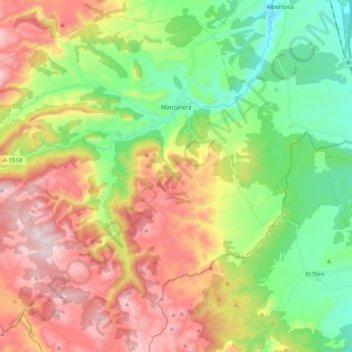
Name: Manzanera topographic map, elevation, terrain.

Location: Manzanera, Gúdar-Javalambre, Teruel, Aragon, Spain (39.95402 -0.96964 40.09894 -0.76205)

Average elevation: 1,224 m

Minimum elevation: 891 m

Maximum elevation: 1,677 m

Other topographic maps

Click on a map to view its topography, its elevation and its terrain.

Los Cerezos

Spain > Aragon > Gúdar-Javalambre > Manzanera

Average elevation: 1,149 m

Peñarroya

Spain > Aragon > Gúdar-Javalambre > Alcalá de la Selva

Average elevation: 1,834 m

Maya

Spain > Aragon > Gúdar-Javalambre > Mora de Rubielos

Average elevation: 1,120 m

Gear up for your next adventure:

🧤Thermal Hiking Gloves - Grip-enhanced gloves for cold-weather altitude trekking
🌬️Windproof Camp Stove - Efficient cooking even on exposed mountain peaks
🧥Fleece Jacket - Warm and lightweight jacket for layering
🧥Packable Rain Jacket - Breathable waterproof layer for unpredictable weather
🧭GPS Tracker - Track your location in remote areas safely

As an Amazon Associate, this site earns from qualifying purchases at no extra cost to you.