
Trabadelo topographic map
Click on the map to display elevation.
About this map
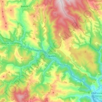
Name: Trabadelo topographic map, elevation, terrain.
Location: Trabadelo, El Bierzo, León, Castile and León, Spain (42.59694 -6.94038 42.71326 -6.80516)
Average elevation: 855 m
Minimum elevation: 480 m
Maximum elevation: 1,445 m
Other topographic maps
Click on a map to view its topography, its elevation and its terrain.
Valtuille de Abajo
Spain > Castile and León > El Bierzo > Villafranca del Bierzo
Average elevation: 525 m
Yacimiento arqueológico La Edrada
Spain > Castile and León > El Bierzo > Cacabelos
Average elevation: 493 m