Geolocate

Hartland topographic map

Click on the map to display elevation.

About this map
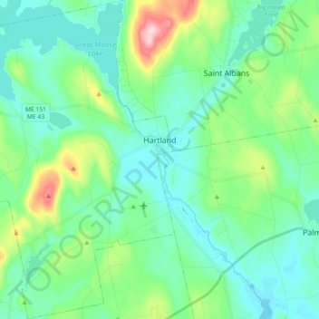
Name: Hartland topographic map, elevation, terrain.

Location: Hartland, Somerset County, Maine, 04943, United States (44.81210 -69.61497 44.93896 -69.43921)

Average elevation: 111 m

Minimum elevation: 59 m

Maximum elevation: 295 m

Other topographic maps

Click on a map to view its topography, its elevation and its terrain.
Pratt Hill

United States > Maine > Somerset County > Skowhegan

Average elevation: 113 m

Bigelow Hill

United States > Maine > Somerset County > Skowhegan

Average elevation: 158 m

Mackamp

United States > Maine > Somerset County

Average elevation: 395 m

Gray Island

United States > Maine > Somerset County > Solon

Average elevation: 105 m

Norris Brook

United States > Maine > Somerset County

Average elevation: 420 m

Gear up for your next adventure:

🧭GPS Tracker - Track your location in remote areas safely
🧥Packable Rain Jacket - Breathable waterproof layer for unpredictable weather
🚲Handlebar Phone Mount - View topographic-map.com live while cycling
👟Leg Gaiters - Keep debris, mud, and snow out of your boots
🧤Insulated Winter Gloves - Heavy-duty protection for sub-zero Canadian adventures

As an Amazon Associate, this site earns from qualifying purchases at no extra cost to you.