
Make a donation
Gear up for your next adventure:
As an Amazon Associate, this site earns from qualifying purchases at no extra cost to you.
Section 14 topographic map
Click on the map to display elevation.
Make a donation
Gear up for your next adventure:
As an Amazon Associate, this site earns from qualifying purchases at no extra cost to you.
About this map
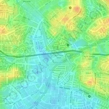
Name: Section 14 topographic map, elevation, terrain.
Location: Section 14, Petaling Jaya, Petaling, Selangor, Malaysia (3.09471 101.62526 3.11297 101.64005)
Average elevation: 39 m
Minimum elevation: 22 m
Maximum elevation: 62 m
Make a donation
Gear up for your next adventure:
As an Amazon Associate, this site earns from qualifying purchases at no extra cost to you.
Other topographic maps
Click on a map to view its topography, its elevation and its terrain.
Kota Damansara Community Forest Reserve
Malaysia > Selangor > Petaling Jaya > Prima Damansara
Average elevation: 85 m
Make a donation
Gear up for your next adventure:
As an Amazon Associate, this site earns from qualifying purchases at no extra cost to you.
Make a donation
Gear up for your next adventure:
As an Amazon Associate, this site earns from qualifying purchases at no extra cost to you.
Taman Subang Indah Kid's Playground & Family Park
Malaysia > Selangor > Petaling Jaya
Average elevation: 25 m