Geolocate

Fontaniva topographic map

Click on the map to display elevation.

About this map

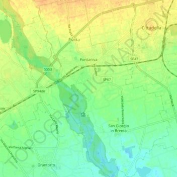
Name: Fontaniva topographic map, elevation, terrain.

Location: Fontaniva, Padova, Veneto, 35014, Italy (45.59657 11.71307 45.65844 11.79317)

Average elevation: 42 m

Minimum elevation: 27 m

Maximum elevation: 58 m

Other topographic maps

Click on a map to view its topography, its elevation and its terrain.

Terrin

Italy > Veneto > Padova > Villatora

Average elevation: 9 m

Camazzole

Italy > Veneto > Padova > Camazzole

Average elevation: 51 m

Gear up for your next adventure:

🥾Trail Running Boots - Durable shoes designed for trail running
🥾All-Terrain Hiking Boots - Versatile boots for varied hiking conditions
🧢Outdoor Cap - Protective cap for sun and rain during hikes
🥘Camping Cookware Set - Compact nesting pots and pans for trail cooking
🎒Hiking Backpack - Lightweight and ergonomic backpacks for day hikes or multi-day treks

As an Amazon Associate, this site earns from qualifying purchases at no extra cost to you.